Search All Items
- Filters:
- Type
- Image 1473
- Still Image 304
- Text 72
- Text 19
- Language
- English 1654
- Spanish 215
- ENGLISH 2
- English 1
- census_013 1
Search Results 1091 to 1100 of 1881
-
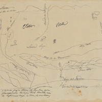
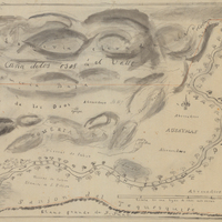
Hand-drawn sketch map of Valle de San Jose boundaries. Volume 1, page 280.
Date: 1826
-
Hand-drawn sketch map of Carrisalitos, or Panoche de San Juan y Carrisalitos, or Rancho de San Juan y Carrisalitos boundaries. Volume 2, page 42.
Date: 1844
-
Hand-drawn sktech map of San Geronimo boundaries. Volume 1, page 752.
Date: 1842
-
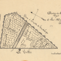
Hand-drawn sketch map of Cañada del Corral boundaries. Volume 1, page 692.
Date: 1840
-
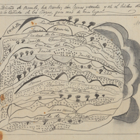
Hand-drawn sketch map of Ausaymas y San Felipe boundaries. Volume 1, page 362.
Date: 1833
-
Hand-drawn sketch map of Mission Vieja de San Rafael boundaries. Volume 2, page 160.
Date: 1845