Search All Items
- Filters:
- Type
- Image 1359
- Still Image 163
- Text 70
- Text 19
- Image of the California Census from the records of the office of the California Secretary of State 1
- Language
- English 1570
- Spanish 41
- ENGLISH 1
- English 1
- census_013 1
- contra_costa_schedule_1_volume_1 1
Search Results 1131 to 1140 of 1624
-
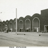
Caption: "Main Entrance," at the Panama-Pacific International Exposition.
Date: 1915
-
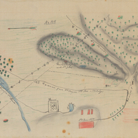
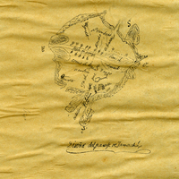
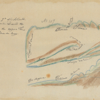
Hand-drawn sketch map of Chichiguas, or San Justo el Viejo and San Bernarbe boundaries. Volume 1, page 306.
Date: 1836
-
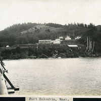
Caption: "Fort Columbia, Wash.," c. 1910. Fort Columbia, built between 1896 and 1904, sits on Chinook Point overlooking the Columbia River. It is part of the Three Fort Harbor Defense System protecting the mouth of the river from enemy incursion or attack (the other forts being Oregon's Fort Stevens and Washington's Fort Canby). Fort Columbia was decommissioned after World War II, and is now the site of a Washington State Park.
Date: 1910
-
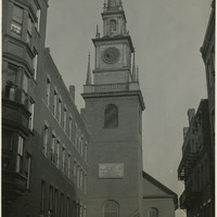
Caption: "Historic North Church, Boston. Where Signal was Hung for Paul Revere, Sept. 5, 1934." View of the clock tower and steeple of the Old North Church, built in 1723. The church is said to be the site where Paul Revere, after his famous midnight ride, caused two lanterns to be hung as the signal that British troops were advancing into the area by sea rather than by land.
Date: 9/5/1934
-
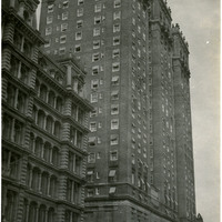
Caption: "Vanderbilt Hotel N.Y," c. 1925. Wealthy businessman Alfred Gwynne Vanderbilt, Sr. had the Vanderbilt Hotel constructed on the site of a former Vanderbilt residence in New York City, just six blocks from the new Grand Central Terminal. Designed by architects Warren & Wetmore, the hotel opened in 1912. The top two stories were constructed as a private residence for Vanderbilt's family. The hotel still stands today, although it has undergone some renovations.
Date: 1925
-
Hand-drawn sketch map of Jamacha, or Jamacho boundaries. Volume 1, page 36.
Date: 1833
-
Hand-drawn sketch map of Corral de Tierra boundaries. Volume 1, page 230.
Date: 1834