Search All Items
- Filters:
- Type
- Image 1359
- Still Image 163
- Text 70
- Text 19
- Image of the California Census from the records of the office of the California Secretary of State 1
- Language
- English 1570
- Spanish 41
- ENGLISH 1
- English 1
- census_013 1
- contra_costa_schedule_1_volume_1 1
Search Results 1151 to 1160 of 1624
-
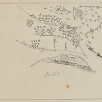
Hand-drawn sketch map of Pastorio de las Borregas boundaries. Volume 1, page 694.
Date: 1840
-
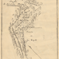
Hand-drawn sketch map of San Diego or San Deiguito boundaries. Volume 2, page 136.
Date: 1845
-
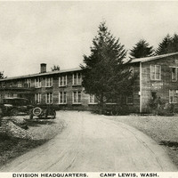
Caption: "Division Headquarters. Camp Lewis, Wash.," c. 1918. Shows the two-story building that served as Division Headquarters for Camp Lewis in Washington. The Camp was established by the U.S. Army in 1917, as part of the U.S.'s preparations for eventual entry into World War I. Rapid construction had the camp ready to house 60,000 men within a few months. The site is still in use as a military facility, under the name Fort Lewis.
Date: 1918
-
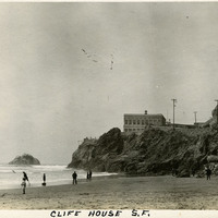
Caption: "Clife [sic] House S.F.," c. 1908-1912. View of San Francisco's Cliff House overlooking Ocean Beach. The building shown here is the fourth iteration of the Cliff House, a neo-classical design built after a fire destroyed the Victorian structure previously at the site in 1907. Reconstruction of the iconic restaurant began in 1908, and a new Cliff House opened in 1909 (the building in this photograph). This neo-classical building was extensively remodeled in the 1930s.
Date: 1908
-
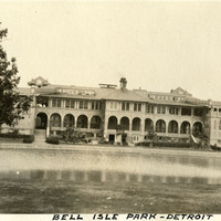
Caption: "Bell [sic] Isle Park - Detroit," c.1925. This photograph features the Belle Isle Casino, on the edge of Lake Tacoma on Belle Isle, in the Detroit River. The building is the second structure at the site, built in 1908 to replace a dilapidated wooden structure. The building is not a gambling facility, but is instead called a "casino" in the older sense of the word: a public building for meetings, dancing, reunions, and other recreation.
Date: 1925