Search All Items
- Filters:
- Type
- Image 1359
- Still Image 163
- Text 70
- Text 19
- Image of the California Census from the records of the office of the California Secretary of State 1
- Language
- English 1570
- Spanish 41
- ENGLISH 1
- English 1
- census_013 1
- contra_costa_schedule_1_volume_1 1
Search Results 1191 to 1200 of 1624
-
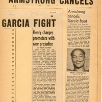
This item has no description.
Date: undated