Search All Items
- Filters:
- Language
- English 6853
- Spanish 18
- ENGLISH 3
- English 2
- census_013 1
- contra_costa_schedule_1_volume_1 1
- Type
- Image 3886
- Still Image 2484
- Text 441
- Text 54
- Textual 2
- Image of the California Census from the records of the office of the California Secretary of State 1
Search Results 111 to 120 of 6969
-
One for Me, At Home, Posner, Fire Smoker, Captain's Own, Our Prospect
Date: 1889
-
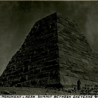
Caption: "This Monument Marks the Spot Where East and West Union Pacific R.R. Was Joined in Completion. Ames Monument, Near Summit Between Cheyenne & Larmie [sic]. Sept. 30, 1934." Grace McCarthy stands in front of the large four-sided pyramid of the Ames Monument in this photograph. The monument, designed by Henry Hobson Richardson, does not mark the spot where the transcontinental railroad was joined (that occurred at Promontory Summit in Utah). Instead, the Ames Monument commemorates brothers Oakes and Oliver Ames, financiers of the Union Pacific Railroad, builder of the eastern portion of the transcontinental railroad line. At the time the pyramid was constructed in 1882, it stood at the highest point in elevation attained by the transcontinental railroad (8,247 feet).
Date: 9/30/1934
-
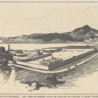
Caption: "New Prison for Segregation of San Quentin Prisoners. View Showing New Dormitory and Prison Yard with Relation to Existing Prison. Mt. Tamalpais in Background." Drawing by Alfred Eichler, September 26, 1934. Project for Department of Corrections.
Date: 1934
-
Office Memorandum from Harry B. White to Martha A. Chickering regarding meeting with Social Security board
Date: February 26, 1943
-
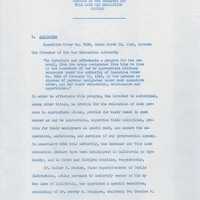
Memorandum regarding planning for the education of incarcerated students
Date: Undated
-
Hand-drawn sketch map of Cañadas or San Julian boundaries. Volume 2, page 26.
Date: 1841
-
Caption: "The Zone" was an area of popular amusements and concession stands at the Panama-Pacific International Exposition. See also 96-07-08-alb01-146.
Date: 1915