Search All Items
- Filters:
- Language
- English 4767
- Spanish 11
- ENGLISH 2
- English 1
- census_013 1
- contra_costa_schedule_1_volume_1 1
- Type
- Image 3783
- Still Image 592
- Text 377
- Text 22
- Textual 2
- Image of the California Census from the records of the office of the California Secretary of State 1
Search Results 1371 to 1380 of 4830
-
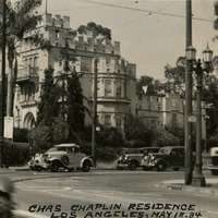
Caption: "Chas Chaplin Residence Los Angeles, May 18, 1934." View of a castle-like building, with crenellated parapets and a tower. William McCarthy labeled this as a residence of Charlie Chaplin. The sign in front appears to indicate that the building is a church rather than a residence, but is difficult to read.
Date: 5/18/1934
-
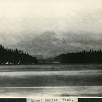
Caption: "Mount Ranier [sic], Wash.," c. 1908-1912. View of Mount Rainier, the highest peak in the Cascade Range and in the state of Washington, and part of the eastern rim of the Pacific Ring of Fire. Although it is now dormant, it is considered to be a high-risk volcano.
Date: 1908
-
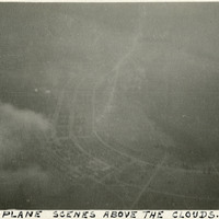
Caption: "Aeroplane [sic] Scenes Above the Clouds.," c. 1915-1920. Photograph taken in an unidentified location, from what appears to have been a biplane (given the small portion of wing that is visible on the left side of the photograph). The locale is unknown.
Date: 1915
-
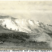
Caption: "Jupiter Terrace - Mammoth Hot Springs - Yellowstone Park," c. 1923. Jupiter Terrace is part of the Lower Terraces of Mammoth Hot Springs. A group of riding horses is seen at lower left, and a road flanks what appear to be observation points at the bottom right.
Date: 1923
-
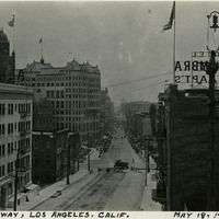
Caption: "Broadway, Los Angeles. Calif. May 18, 1934." Street scene showing a view of Broadway in Los Angeles. Hotel Alhambra is visible in the foreground on both sides of the street, while the clock tower of the Los Angeles County Courthouse is visible at the left.
Date: 5/18/1934
-
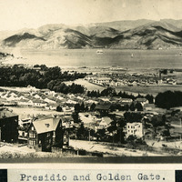
Caption: "Presidio and Golden Gate," c. 1906, shows many Presidio buildings pictured in the foreground, with ships in the bay. Established in 1776 by Spanish explorers, the Presidio is a fortified location overlooking the Golden Gate, the entrance into San Francisco Bay. It was closed as a military structure in 1995, and is now a park within the Golden Gate National Recreation Area.
Date: 1906
-
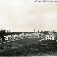
Caption: "Fort Stevens, Oregon," c. 1905. Panorama of Fort Stevens, built in the 1860s as part of the defensive fortifications guarding the mouth of the Columbia River. Located on the Oregon side of the river, the fort was decommissioned after World War II, its armaments and buildings removed and auctioned off. The site now serves as a state park complete with military museum.
Date: 1905
-
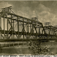
Caption: "Mississippi River Bridge. Rock Island to Davenport, Iowa. Sept. 25, 1934." View of the Government Bridge spanning the Mississippi River between Rock Island and Davenport, Iowa. Built in 1896 and designed by Ralph Modjeski, the bridge in this photograph was the fourth bridge constructed at the site, replacing earlier structures made obsolete by the increasing volume and changing character of traffic. This double-decker bridge connected the U.S. arsenal on Rock Island with Davenport, Iowa, and featured a double rail road track, a separate deck for automobiles, and a swing section. The bridge is still in use today.
Date: 9/25/1934
-
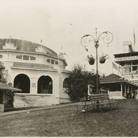
No Caption: See also 96-07-08-alb05-185, with caption: "Council Crest -- Portland," Buildings and benches in a park setting, with a tall observation tower, labeled the "Observatory," at the right side of the photograph. Council Crest Park in Portland, Oregon was the site of an amusement park between 1907 and 1929. The buildings in this photograph were part of that park. The Observatory, built in 1907, was demolished in 1941 to make room for a water tower. The area is still in use as a municipal park.
Date: 1909
-
Caption: "Tamalpais Views," is a label for photographs 179 - 184 in album 6, showing a variety of views of Mount Tamalpais in Marin County.
Date: Undated