Search All Items
- Filters:
- Type
- Image 3871
- Still Image 1541
- Text 433
- Text 19
- Image of the California Census from the records of the office of the California Secretary of State 1
- Language
- English 5808
- Spanish 62
- ENGLISH 2
- English 1
- census_013 1
- contra_costa_schedule_1_volume_1 1
Search Results 1771 to 1780 of 5932
-
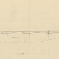
Design and drawing of elevation for bridge in Twin Trees, Humboldt County, by Alfred Eichler. Project for Department of Public Works - Highways - Bridge Department.
Date: 1933
-
Image withheld due to copyright considerations. For more information, please contact the California State Archives Reference Desk at ArchivesWeb@sos.ca.gov or (916) 653-2246. Image is a map of the United States showing "Our 1934 United States Automobile Tour. Traveled 10,000 miles -- May 14 to Oct 9.th. Note the Blue Line for Route of Travel." The blue line stretches from San Francisco to Los Angeles, then along the southern portion of the U.S. into Florida, south to Havana, and then north along the East Coast until heading east from Boston. The route skirted the Great Lakes then struck out across the Great Plains, Colorado, and Nevada, before ending in San Francisco to complete the loop.
Date: 1934
-
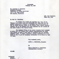
Correspondence from Martha A. Chickering to Richard H. Neustadt regarding exemption from incarceration in mixed marriage cases; See F3729_86_001 and F3729_86_003
Date: February 10, 1943
-
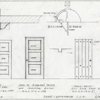
Caption: "Doors - Natatorium S. L. O." Design and drawing of natatorium doors, California State Polytechnic College, San Luis Obispo, by Alfred Eichler. Built. Project for Department of Education.
Date: 1936
-
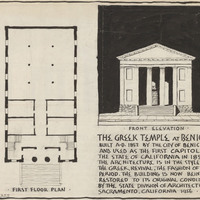
Illustration of Benicia State Capitol by Alfred Eichler. Includes first floor plan, front elevation, and informational text. Project for Department of Natural Resources - Beaches and Parks.
Date: 1956
-
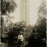
Caption: "Bok Singing Tower, Lake Wales -- Florida, June 26, 34." William McCarthy stands in Bok Tower Gardens, a 250-acre contemplative garden and bird sanctuary dedicated in 1929. The centerpiece of the gardens appears behind William: the Bok Singing Tower. The 205-foot-tall tower, designed by architect Milton B. Medary, was completed by February 1929. It features Gothic revival and Art Deco detailing. A 60-bell carillon can be played by a clavier (keyboard) in the bell chamber.
Date: 6/24/1934
-
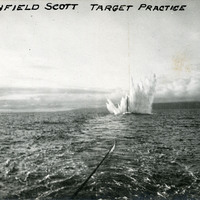
Caption: "Fort Winfield Scott Target Practice." This postcard shows a plume of seawater thrown up by a mortar shell during target practice at Fort Point. Fort Point was part of an effort by the U.S. government to protect the Golden Gate, entrance to the San Francisco Bay. Built between 1853-1861, the fort included emplacements for 141 guns but never fired a weapon in defense of the Bay. Its name was officially changed in 1882 to Fort Winfield Scott. This only lasted four years, however, for in 1886 the fort was officially downgraded to a sub-post of the San Francisco Presidio and the name discontinued. It was resurrected in 1912, with the establishment of a coastal artillery fortification at the Presidio, called, once again, Fort Winfield Scott. See also 96-07-08-alb08-029.
Date: 1909-10-25
-
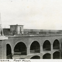
Caption: "Portion of Interior. Fort Point.," c. 1906. View of arched colonnades on ground and middle floors of Fort Point, and an upper tier with barbettes for the future installation of heavy artillery coastal defense weapons. The facilities at Fort Point were part of an effort by the U.S. government to protect the Golden Gate, entrance to the San Francisco Bay. Built between 1853-1861, the fort included emplacements for 141 guns but never fired a weapon in defense of the Bay. Its name was officially changed in 1882 to Fort Winfield Scott, but in 1886 the fort was officially downgraded to a sub-post of the San Francisco Presidio and the name discontinued. It was resurrected in 1912, with the establishment of a coastal artillery fortification at the Presidio, called, once again, Fort Winfield Scott.
Date: 1906
-
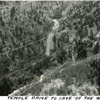
Caption: "Temple Drive to Cave of the Winds," c. 1923. Bird's eye view of a road at the bottom of a canyon, on a drive to Cave of the Winds. Two brothers discovered the entrance to the large cave system in 1880, in Williams Canyon just outside of Manitou Springs. Further exploration resulted in opening more caverns within the system, and the site became a tourist attraction, with guided tours having been on offer since 1881.
Date: 1923
-
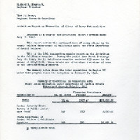
Correspondence from Vlad F. Ratay to Richard M. Neustadt regarding weekly report on activities of State Department of Social Welfare
Date: July 24, 1942