Search All Items
- Filters:
- Type
- Image 3872
- Still Image 1847
- Text 428
- Text 50
- Image of the California Census from the records of the office of the California Secretary of State 1
- Language
- English 6191
- Spanish 11
- ENGLISH 2
- English 2
- census_013 1
- contra_costa_schedule_1_volume_1 1
Search Results 1871 to 1880 of 6265
-
Correspondence from John H. Provinse to T. G. Ishimaru regarding Manzanar Children's Village and reestablishment of a children's home
Date: June 15, 1945
-
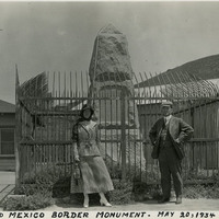
Caption: "U. S. and Mexico Border Monument. May 20, 1934." William and Grace McCarthy standing in front of the monument placed at the U.S.-Mexico border in Tijuana, Mexico.
Date: 5/20/1934
-
Correspondence from Earl Warren (by Sherrill Halbert) to C. C. McDonald regarding Alien Land Law maps and locating Japanese
Date: March 16, 1942
-
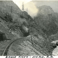
Caption: "Eagle River - D. & R. G. R. R," c. 1923. Denver and Rio Grande Western Railroad tracks run next to the Eagle River at the bottom of a canyon in this photograph, toward a tunnel with steam or smoke coming out of the entry. The Denver and Rio Grande (D&RG) primarily operated railroad lines between Denver, Colorado and Salt Lake City, Utah, with other lines stretching into New Mexico.
Date: 1923
-
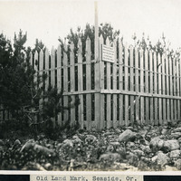
Caption: "Old Landmark, Seaside, Or.," c. 1910. Shows a picket fence erected around what a sign calls "Remains of Cairn where Lewis & Clark made salt from the ocean water Jan. & Feb. 1806." When the famous expedition led by Merriweather Lewis and William Clark reached the Pacific Ocean in late 1805, their supplies had run dangerously low, including their salt supply. Salt, used not only to flavor meat but also to preserve it, was extremely important to the health of the expedition. Three of Lewis and Clark's men traveled to a site on the coast near present-day Seaside, Oregon to set up a small salt-works, boiling ocean water in a series of large kettles and then scraping the resulting salt crust off of the sides. In this manner, the men eventually collected about twenty gallons of salt before Lewis and Clark decided the supply was sufficient for the return journey. In 1910, the property containing the remains of the cairns was deeded to the Oregon Historical Society. In 1955, replica salt cairns were built at the site by the Lions Club to commemorate the expedition's activities.
Date: 1910
-
Correspondence from Bertha S. Underhill to Mary LeHane regarding assistance and deportation; response to Memo on Fear of Deportation (F3729_109_001b)
Date: April 6, 1945
-
Memorandum from O. J. Jahnsen regarding various residents and domestic workers of Japanese descent in a San Francisco apartment
Date: February 16, 1942
-
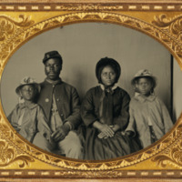
This item has no description.
Date: Circa 1865
-
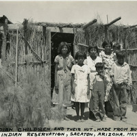
Caption: "Pima Indian Children and Their Hut, Made from Bush Branches, Sacaton Indian Reservation, Sacaton, Arizona. May 24, 1934." Several children of the Akimel O'odham (Pima) tribe in front of a hut made with tree branches and wood beams, its walls and roof thatched in brush. Located south of Phoenix and including the town of Sacaton, the Gila River Indian Reservation is home to members of the Akimel O’odham (Pima) and the Pee-Posh (Maricopa) tribes. The reservation was established in 1859. Eighty years later, in 1939, Congress provided for the self-governance of the reservation via the Gila River Indian Community.
Date: 5/24/1934