Search All Items
- Filters:
- Type
- Image 3851
- Still Image 1032
- Text 431
- Text 19
- Language
- English 5293
- Spanish 43
- ENGLISH 2
- English 1
- census_013 1
Search Results 1871 to 1880 of 5402
-
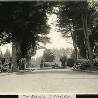
Caption: "The Alameda of Presidio," c. 1906. View of a dirt or graveled drive, lined by cannonballs, leading to a small roundabout. The Alameda served as the principle gateway into the Presidio of San Francisco from the 1860s to 1895.
Date: 1906
-
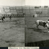
Caption: "Placing the Bandarillias [sic]." Two images pasted into the photograph album next to each other, both showing bulls in a bullring. In both photographs, banderilleros are attempting to place banderillas (short barbed sticks) in each bull's shoulders.
Date: 1905
-
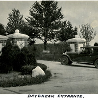
Caption: "Daybreak Entrance." A man pauses for a quick photo sitting in his car at the entrance to a private road leading to the Daybreak Estate area of Long Island.
Date: 1934
-
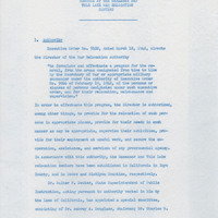
Memorandum regarding planning for the education of incarcerated students
Date: Undated
-
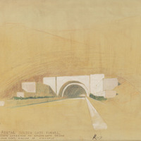
Caption: "South Portal Golden Gate Tunnel. Marin County approach to Golden Gate Bridge." Design and drawing by Alfred Eichler. Built. Project for Department of Public Works - Highways - Bridge Department.
Date: 1938
-
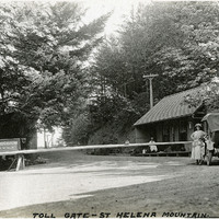
Caption: "Toll Gate -- St Helena Mountain.," c. 1920. Toll gate consists of a long wooden spar across the road, with a small building to the right. Grace McCarthy is standing next to an automobile at the gate. The St. Helena Toll Road, now part of California State Route 29, connected the Napa Valley with Lake County. It was built in 1868, and purchased by the State of California in 1925.
Date: 1920
-
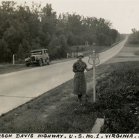
Caption: "Jefferson Davis Highway. U.S. No. 1. Virginia. July 20, 34." Grace McCarthy is standing next to a U.S. Route 1 sign along a highway in Virginia. The Jefferson Davis Highway project was begun by the United Daughters of the Confederacy (UDC). As auto tourism increased across the U.S., so to did the need for roads on which to drive. Private interests such as the UDC began to develop routes across the country, but with no central administrating organization the routes were haphazard and confusing. The UDC planned a route that was to stretch from Virginia across the southern U.S. to San Diego, but the entire route never materialized. The federal government stepped in to impose a numbering system on various routes across the nation. That portion of the planned Jefferson Davis Highway through Virginia was numbered as U.S. Route 1.
Date: 7/20/1934
-
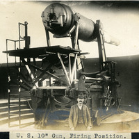
Caption: "U. S. 10" Gun, Firing Position.," c. 1905. William McCarthy standing next to a 10" disappearing gun, raised to its firing position. Retracting or disappearing guns were a form of artillery developed in the nineteenth century in which heavy artillery guns were placed on rotating carriages that allowed retraction of the weapon after firing, to enable reloading while under enemy fire.
Date: 1905
-
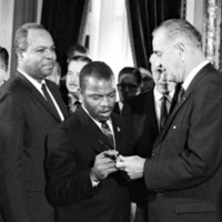
This item has no description.
Date: 1965
-
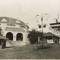
No Caption: See also 96-07-08-alb05-185, with caption: "Council Crest -- Portland," Buildings and benches in a park setting, with a tall observation tower, labeled the "Observatory," at the right side of the photograph. Council Crest Park in Portland, Oregon was the site of an amusement park between 1907 and 1929. The buildings in this photograph were part of that park. The Observatory, built in 1907, was demolished in 1941 to make room for a water tower. The area is still in use as a municipal park.
Date: 1909