Search All Items
- Filters:
- Type
- Image 3888
- Still Image 2857
- Text 431
- Text 50
- Image of the California Census from the records of the office of the California Secretary of State 1
- Language
- English 7190
- Spanish 43
- ENGLISH 3
- English 2
- census_013 1
- contra_costa_schedule_1_volume_1 1
Search Results 2011 to 2020 of 7317
-
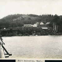
Caption: "Fort Columbia, Wash.," c. 1910. Fort Columbia, built between 1896 and 1904, sits on Chinook Point overlooking the Columbia River. It is part of the Three Fort Harbor Defense System protecting the mouth of the river from enemy incursion or attack (the other forts being Oregon's Fort Stevens and Washington's Fort Canby). Fort Columbia was decommissioned after World War II, and is now the site of a Washington State Park.
Date: 1910
-
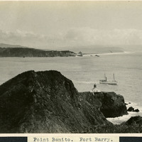
Caption: "Point Benito [sic]. Fort Barry." c. 1910. A view of the Point Bonita Lighthouse near Fort Barry and the Marin Headlands. The lighthouse, built in 1855, was the third lighthouse built on the West Coast to shepherd ships through the narrow straights of the Golden Gate. The lighthouse, still active today, is maintained by the U.S. Coast Guard, and is part of the Golden Gate National Recreation Area.
Date: 1910
-
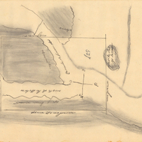
Hand-drawn sketch map of Canada de la Berrenda boundaries. Volume 2, page 196.
Date: 1846
-
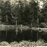
Caption: "Stanley Park Vancouver B.C.," c. 1908-1912. Shows a pond with central fountain, surrounded by lush vegetation including evergreen trees. A group of people stands at the pond's edge in the distance. The City of Vancouver opened Stanley Park in 1888. The 405-hectare park is even now thickly forested, and remains Vancouver's largest park. It is located on the northern edge of the city, surrounded on three sides by Vancouver Harbor and English Bay.
Date: 1908