Search All Items
- Filters:
- Type
- Image 3851
- Still Image 1032
- Text 431
- Text 19
- Language
- English 5293
- Spanish 43
- ENGLISH 2
- English 1
- census_013 1
Search Results 2061 to 2070 of 5402
-
Image withheld due to copyright considerations. For more information, please contact the California State Archives Reference Desk at ArchivesWeb@sos.ca.gov or (916) 653-2246. Caption: "San Francisco, Down Town and Bay Bridge. Feb. 1, 1938." Postcard showing what appears to be an artist's rendition of downtown San Francisco and the San Francisco-Oakland Bay Bridge.
Date: 2/1/1938
-
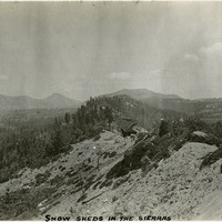
Caption: "Snow Sheds in the Sierras." Mountain scene with snow sheds, used to shelter trains from winter storms, in center of photograph.
Date: 1927
-
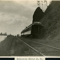
Caption: "Columbia River R. R.," c. 1910. View of railroad tracks along the Columbia River, with some train cars next to a high bank or cliff.
Date: 1910
-
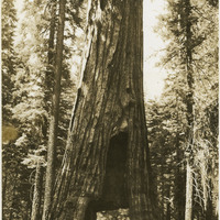
No Caption: A tunnel tree in Yosemite National Park, with a sign next to it reading: "California HGT: 246' DIAM: 21'," c. 1935.
Date: 1935
-
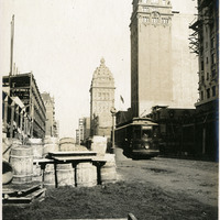
Caption: "Fourth and Market, One Year Later," 1907, shows much construction in progress, and completed, to the street and buildings one year after the 1906 earthquake and fires.
Date: 1907
-
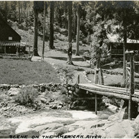
Caption: "Scene on the American River," c. 1920. Narrow bridge over river, leading to two houses, with sign stating "3. F. Rancho. 1915."
Date: 1920
-
Image withheld due to copyright considerations. For more information, please contact the California State Archives Reference Desk at ArchivesWeb@sos.ca.gov or (916) 653-2246. Image is a map of the United States showing "Our 1934 United States Automobile Tour. Traveled 10,000 miles -- May 14 to Oct 9.th. Note the Blue Line for Route of Travel." The blue line stretches from San Francisco to Los Angeles, then along the southern portion of the U.S. into Florida, south to Havana, and then north along the East Coast until heading east from Boston. The route skirted the Great Lakes then struck out across the Great Plains, Colorado, and Nevada, before ending in San Francisco to complete the loop.
Date: 1934
-
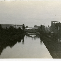
Caption: "Venice," c. 1911. View of canal and bridge in Venice, California, with amusement "zone" in the distance. In 1905, Abbot Kinney built a series of canals as part of a development project along Santa Monica Beach, hoping to recreate the look and feel of Italy's iconic "Floating City" in southern California. Called Ocean Park at first, in 1911, the name officially changed to Venice. By 1929, however, many of the canals had been filled in to create roadways, and those that remained fell into disrepair. A revitalization movement in the early 1990s has restored some of the canals, and made the area a desirable residential neighborhood.
Date: 1911
-
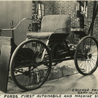
Caption: "Henry Ford's First Automobile and Machine Shop, Chicago Fair Exhibit. Sept. 19, 1934." This exhibit within the Ford Building at Chicago's Century of Progress Exposition replicated Henry Ford's original workshop, including a Quadricycle, the first automobile produced by Ford. The Exposition, a world fair attended by thirty-nine million people, celebrated Chicago's one-hundred year anniversary of incorporation. Originally planned to only run from May to November in 1933, it was such a success that its organizers decided to keep it running for a second season from May through October the following year. The central theme of the Exposition was technological innovation, with a motto of "Science Finds, Industry Applies, Man Conforms."
Date: 9/19/1934
-
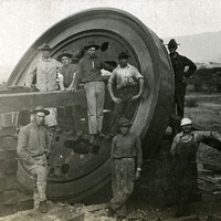
No caption, c. 1909-1915. Group of unidentified men gathered around a part of what appears to be a 12-inch mortar at Fort Ruger, Hawaii. Fort Ruger was established on the Island of O'ahu by the U.S. in 1906 as the Diamond Head Reservation. Its name was changed to Fort Ruger in 1909. See also 96-07-08-alb05-098 and 100.
Date: 1915