Search All Items
- Filters:
- Type
- Image 3872
- Still Image 1847
- Text 428
- Text 50
- Image of the California Census from the records of the office of the California Secretary of State 1
- Language
- English 6191
- Spanish 11
- ENGLISH 2
- English 2
- census_013 1
- contra_costa_schedule_1_volume_1 1
Search Results 2101 to 2110 of 6265
-
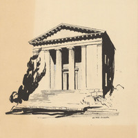
Design and drawing by Alfred Eichler for brochure for Benicia State Capitol restoration. Project for Department of Natural Resources - Beaches and Parks.
Date: 1957
-
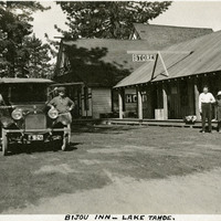
Caption: "Bijou Inn -- Lake Tahoe.," c. 1915-1920. William and Grace McCarthy standing next to automobile near Bijou Inn and store in the Lake Tahoe area.
Date: 1920
-
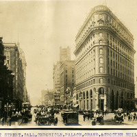
Caption: Market Street, Call, Chronicle, Palace, Grand, & Crocker Buildings," c. 1906, shows a bustling scene of tall buildings, people, horses and buggies, and a trolley on Market Street.
Date: 1906
-
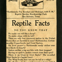
One side of a flier handed out by the San Antonio Reptile Garden in the mid-1930s entitled "Reptile Facts." The Reptile Garden opened in the 1930s as a fundraising facility for the Witte Museum. The Garden featured turtle races, snake handling demonstrations, fried rattlesnake meat, and rattlesnake dinner fund raisers. It also became a research center for the use of antivenom. The Garden closed in the early 1940s, its live snakes donated to the San Antonio Zoo.
Date: 1934
-
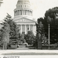
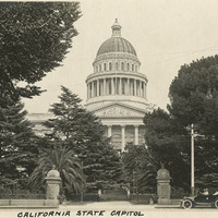
Caption: "State Capitol, Sacramento," c. 1910. The Capitol building in Sacramento, California. Located on the west end of Capitol Park, the neoclassical building's construction began in 1860 and was completed in 1874. It houses the state legislature and offices of the governor. The capitol and grounds were listed on the National Register of Historic Places in 1973, and as a California Historical Landmark in 1974.
Date: 1910
-
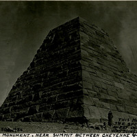
Caption: "This Monument Marks the Spot Where East and West Union Pacific R.R. Was Joined in Completion. Ames Monument, Near Summit Between Cheyenne & Larmie [sic]. Sept. 30, 1934." Grace McCarthy stands in front of the large four-sided pyramid of the Ames Monument in this photograph. The monument, designed by Henry Hobson Richardson, does not mark the spot where the transcontinental railroad was joined (that occurred at Promontory Summit in Utah). Instead, the Ames Monument commemorates brothers Oakes and Oliver Ames, financiers of the Union Pacific Railroad, builder of the eastern portion of the transcontinental railroad line. At the time the pyramid was constructed in 1882, it stood at the highest point in elevation attained by the transcontinental railroad (8,247 feet).
Date: 9/30/1934
-
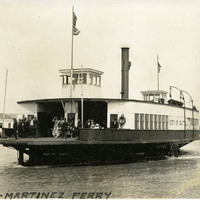
Caption: "Benicia-Martinez Ferry," c. 1913. View of the City of Seattle, a steam-powered ferry built in 1888. Purchased in 1913 by the Martinez and Benicia Ferry and Transportation Company, the City of Seattle served as a ferry between Benicia and Martinez until being requisitioned by the U.S. Navy in 1944.
Date: 1913
-
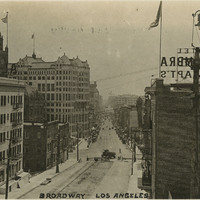
Caption: "Broadway, Los Angeles." Broadway is a major thoroughfare of Los Angeles and one of the oldest in the city, laid out in 1849 as Fort Street, and renamed Broadway in 1890. In this image, construction can be seen at the top of the street between the two buildings of the Alhambra Hotel and Apartments. May 18, 1934. See also 96-07-08.alb11.006.
Date: 1934
-
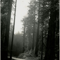
Caption: "Redwood Highway near Crescent City," c. 1935. U.S. Route 101, or the Redwood Highway as it is known in northern California, was established in 1926. It is also known as El Camino Real (The Royal Road) along the southern and central California Coast and approximates the old trail that linked the missions, pueblos, and presidios of the Spanish era.
Date: 1935
-
Caption: "California State Capitol." Shows the California State Capitol building and grounds. Located on the west end of Capitol Park, the neoclassical building's construction began in 1860 and was completed in 1874. It houses the state legislature and offices of the governor. The capitol and grounds were listed on the National Register of Historic Places in 1973, and as a California Historical Landmark in 1974. A parked automobile in the foreground has Grace McCarthy at the wheel, with William McCarthy sitting beside her, and two unidentified people in the backseat, Sacramento, c. 1915.
Date: 1915