Search All Items
- Filters:
- Type
- Image 3851
- Still Image 1032
- Text 431
- Text 19
- Language
- English 5293
- Spanish 43
- ENGLISH 2
- English 1
- census_013 1
Search Results 2111 to 2120 of 5402
-
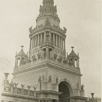
Caption: "Tower of Jewels," at the Panama-Pacific International Exposition. The Panama Pacific International Exposition was held to celebrate the completion of the Panama Canal, as well as inventive technologies and new industries from around the world. It was also a chance for San Francisco to show the world how the great city had rebuilt and thrived after the devastation of the 1906 earthquake and fire.
Date: 1915
-
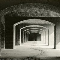
Caption: "Fort Point -- Interior," c. 1910. Postcard showing a view of an interior hall or walkway featuring several arches at Fort Point. The facilities at Fort Point were part of an effort by the U.S. government to protect the Golden Gate, entrance to the San Francisco Bay. Built between 1853-1861, the fort included emplacements for 141 guns but never fired a weapon in defense of the Bay. Its name was officially changed in 1882 to Fort Winfield Scott, but in 1886 the fort was officially downgraded to a sub-post of the San Francisco Presidio and the name discontinued. It was resurrected in 1912, with the establishment of a coastal artillery fortification at the Presidio, called, once again, Fort Winfield Scott.
Date: 1910
-
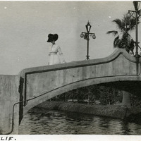
Caption: "Venice, Calif," c. 1911. Unidentified woman standing on a bridge over Lion Canal in Venice, California. In 1905, Abbot Kinney built a series of canals as part of a development project along Santa Monica Beach, hoping to recreate the look and feel of Italy's iconic "Floating City" in southern California. Called Ocean Park at first, gondoliers sailed boats under elegant bridges such as the one shown in this photograph, in an effort to attract businesses, residents, and investors. In 1911, the name officially changed to Venice. By 1929, however, many of the canals had been filled in to create roadways, and those canals that remained fell into disrepair. A revitalization movement in the early 1990s has restored some of the canals, and made the area a desirable residential neighborhood.
Date: 1911
-
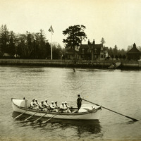
No Caption: c. 1910. View of the Point Adams Lifesaving Station near Hammond, Oregon, including a rowboat ("Point Adams") manned by eight rowers, with one man at the rudder. The Point Adams Lifesaving Station was established in 1889 by the federal government, in response to growing numbers of merchant, fishing, and other sailing vessels along the Columbia River. The stationhouse, visible in the center of the photograph, was demolished in 1939 to make way for a new building. The two-bay boathouse visible at the right had to be moved in 1913-1915 due to erosion of the bank upon which it stood. The U.S. Coastguard took over operation of the station in 1915. The station remained operational until 1967. The remaining buildings now house the Point Adams Research Facility of the Northwest Fisheries Science Center.
Date: 1910
-
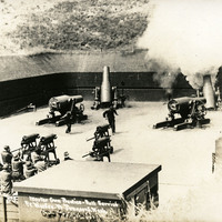
Caption: "Mortar Gun Practice -- Full Service, Fort Worden, Pt Townsend, Wash," c. 1910. The postcard shows several Howitzers, one of which is firing, as well as a group of men standing to the side with their hands over their ears. Construction began on Fort Worden in 1898, and by 1902 it was serving as an active U.S. Army base. Fort Worden was part of the "triangle of fire," three coastal defense fortifications (Fort Casey, Fort Worden, and Fort Flagler) guarding the entrance to Puget Sound. The U.S. sold the property to the state of Washington in 1957. In 1973, the fort and surrounding area opened as Fort Worden State Park.
Date: 1910
-
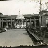
Caption: "A.Y.P.E. Seattle Oregon Bldg." View of Oregon Building and bandstand, part of the Alaska-Yukon-Pacific Exposition. Held in Seattle to celebrate the development of the Pacific Northwest, the fair attracted 3.7 million visitors over the course of its run from June to October 1909. Although most of the fair's buildings have since been destroyed, several of them now serve as part of the University of Washington campus.
Date: 1909
-
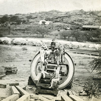
No caption, c. 1909-1915. Group of unidentified men gathered around a part of what appears to be a 12-inch mortar at Fort Ruger, Hawaii. Farm buildings and rolling hills appear in the distance. Fort Ruger was established on the Island of O'ahu by the U.S. in 1906 as the Diamond Head Reservation. Its name was changed to Fort Ruger in 1909. See also 96-07-08-alb05-098 and 099.
Date: 1915
-
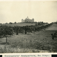
Caption: "Theosophists' Headquarters, San Diego.," c. 1905. Palm-lined driveway leading to two large buildings. The Raja Yoga Academy is visible in the center of the photograph, featuring a domed roof and domed turrets at each of the building's corners. At the right stands the Temple of Peace. Both are buildings within the Theosophist complex called Lomaland. The complex housed Theosophists from 1900 to 1942. The area is now part of Point Loma Nazarene University.
Date: 1905
-
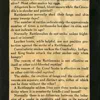
One side of a flier handed out by the San Antonio Reptile Garden in the mid-1930s entitled "Reptile Facts." The Reptile Garden opened in the 1930s as a fundraising facility for the Witte Museum. The Garden featured turtle races, snake handling demonstrations, fried rattlesnake meat, and rattlesnake dinner fund raisers. It also became a research center for the use of antivenom. The Garden closed in the early 1940s, its live snakes donated to the San Antonio Zoo.
Date: 1934
-
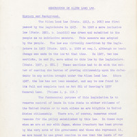
Summary of the history of the Alien Land Laws including deciding court cases; Sections: History and Background, Provisions of Existing Law; Persons Affected by this Law, Property Affected by the Law
Date: Undated