Search All Items
- Filters:
- Type
- Image 3854
- Still Image 1906
- Text 414
- Text 19
- Language
- English 6003
- Spanish 194
- ENGLISH 2
- English 1
- census_013 1
Search Results 2601 to 2610 of 6250
-
No Caption: c. 1915, shows a monument with a statue of Stephen M. White on the grounds of the Los Angeles County Courthouse. Stephen M. White, a former Los Angeles district attorney, served in the California Senate, as well as acting Lieutenant Governor from 1887-1891. He also served in the United States Senate from 1893 -1899. White was also responsible for the creation of Los Angeles Harbor in San Pedro. The monument was moved in 1989 to the entrance of Cabrillo Beach near the harbor where it resides today.
Date: 1915
-
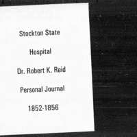
A series of short notations about hospital patients under the supervision of Dr. Reid. Volumes one through four in this series run chronologically, starting in 1852 and ending in 1856. The entries include details such as patient name, nationality, and age, as well as mental disposition. A researcher with an interest in a particular hospital patient may find Reidà¿s journals useful. Dr. Robert K. Reid's medical journals do not include private thoughts about the medical profession or details about Reid's role as a physician at Stockton State Hospital. The fifth volume in the series contains Dr. Reid's Meteorological Observations. Beginning in 1850, Reid recorded daily meteorological observations, including three daily temperature recordings, taken at 8 a.m., 2 p.m., and 8 p.m.. He also recorded cloud, wind, and rain observations, and in 1853, began recording daily barometric pressures. Dr. Robert K. Reid's Meteorological Observations journal continues through 1856.
Date: 1850-1856
-
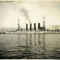
Caption: "The California. " c. 1906. This photograph shows the second U.S. Navy ship to bear the Golden State's name. Launched in 1904 and commissioned in 1907, this Pennsylvania-class armored cruiser served in the Pacific fleet. Her name was changed in 1914 to the USS San Diego, in order to free up the name for a new, Tennessee-class battleship. The USS San Diego went on to serve in both the Pacific and Atlantic fleets during World War I, until being sunk off the coast of New York by a German mine in 1918, with a loss of six lives.
Date: 1906
-
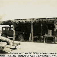
Caption: "Indian Hut Made From Adobe and Bush Branches, Sacaton Indian Reservation, Sacaton, Arizona, May, 24, 1934." View of a small adobe building with a porch area across the length of the façade. The porch is sheltered by a low roof supported by tree trunks or thick tree branches and thatched with grass or sticks. Located south of Phoenix and including the town of Sacaton, the Gila River Indian Reservation is home to members of the Akimel O’odham (Pima) and the Pee-Posh (Maricopa) tribes. The reservation was established in 1859. Eighty years later, in 1939, Congress provided for the self-governance of the reservation via the Gila River Indian Community.
Date: 5/24/1934
-
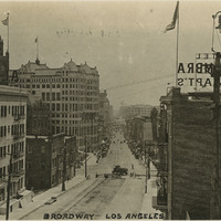
Caption: "Broadway, Los Angeles." Broadway is a major thoroughfare of Los Angeles and one of the oldest in the city, laid out in 1849 as Fort Street, and renamed Broadway in 1890. In this image, construction can be seen at the top of the street between the two buildings of the Alhambra Hotel and Apartments. May 18, 1934. See also 96-07-08.alb11.006.
Date: 1934
-
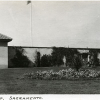
Caption: "Sutter [sic] Fort. Sacramento.," c. 1920. A gun tower at Sutter's Fort, and a gate bracketed by two cannons. John Sutter established the fort in 1839, calling it New Helvetia. After the discovery of gold at one of Sutter's mills (at Coloma, on the American River), almost all of the fort's inhabitants left for the gold fields in the foothills. The fort deteriorated until being restored from 1891-1893. The fort is now the site of a State Historic Park. See also 96-07-08-alb05-118.
Date: 1920
-
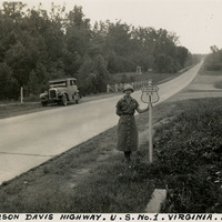
Caption: "Jefferson Davis Highway. U.S. No. 1. Virginia. July 20, 34." Grace McCarthy is standing next to a U.S. Route 1 sign along a highway in Virginia. The Jefferson Davis Highway project was begun by the United Daughters of the Confederacy (UDC). As auto tourism increased across the U.S., so to did the need for roads on which to drive. Private interests such as the UDC began to develop routes across the country, but with no central administrating organization the routes were haphazard and confusing. The UDC planned a route that was to stretch from Virginia across the southern U.S. to San Diego, but the entire route never materialized. The federal government stepped in to impose a numbering system on various routes across the nation. That portion of the planned Jefferson Davis Highway through Virginia was numbered as U.S. Route 1.
Date: 7/20/1934
-
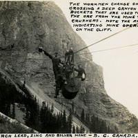
Caption: "The Monarch Lead, Zinc, and Silver Mine - B.C. Canada. The workmen change shifts by crossing a deep canyon in the buckets that are used to transport the ore from the mine to the rock crushers. Note the arrows indicating mine operations on the cliff," c. 1935.
Date: 1935
-
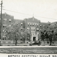
Caption: "Sisters Hospital -- Walla Walla.," ca. 1920. Five-story brick and stone building. This building is the second hospital built on the site. The first, built in the 1880s by the Sisters of Providence, burned in a 1915 fire. This second building (seen here), constructed in 1916, served as the main hospital building until a new facility was constructed in 1976. The resulting new complex of buildings is now called the Providence St. Mary Medical Center.
Date: 1920
-
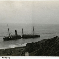
Caption: "S.S. Santa Rosa." Wreck of the S.S. Santa Rosa off Point Arguello in Santa Barbara County. The steamship ran aground on July 6, 1911. Unable to break free, the turbulent waters eventually cracked the ship in half. All two hundred passengers got to shore alive, the only fatalities coming when four sailors were accidentally thrown out of a lifeboat by rough seas while attempting to establish a land line to stabilize the wreck.
Date: 1911