Search All Items
- Filters:
- Type
- Image 3886
- Still Image 2481
- Text 427
- Text 50
- Image of the California Census from the records of the office of the California Secretary of State 1
- Language
- English 6833
- Spanish 18
- ENGLISH 3
- English 2
- census_013 1
- contra_costa_schedule_1_volume_1 1
Search Results 2661 to 2670 of 6929
-
Correspondence from Charles M. Wollenberg (by Ruth E. Rogers) to Beulah L. Lewis regarding resettlement aid
Date: September 10, 1946
-
This item has no description.
Date: undated
-
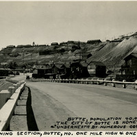
Caption: "Butte, population 40,000. The city of Butte is honeycombed underneath by numerous copper mines. The mining section, Butte, Mo. one mile high & one mile deep," c. 1935.
Date: 1935
-
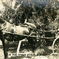
Caption: "In the Shade of the Old Apple Tree," shows William McCarthy sitting in a horse-drawn buggy next to an apple tree, likely on the McCarthy property in Watsonville, c. 1906.
Date: 1906
-
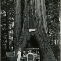
Caption: "The Coolidge Redwood Tree. Redwood Highway, Calif.," c. 1935. William and Grace pose with their automobile at the Coolidge Redwood Tree on the Redwood Highway in Mendocino County, named after Col. John Coolidge, father of President Calvin Coolidge.
Date: 1935
-
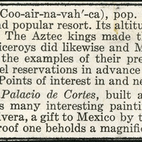
No Caption: A section from an informational tourist brochure describing the city of Cuernavaca in the state of Morelos.
Date: 1938
-
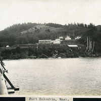
Caption: "Fort Columbia, Wash.," c. 1910. Fort Columbia, built between 1896 and 1904, sits on Chinook Point overlooking the Columbia River. It is part of the Three Fort Harbor Defense System protecting the mouth of the river from enemy incursion or attack (the other forts being Oregon's Fort Stevens and Washington's Fort Canby). Fort Columbia was decommissioned after World War II, and is now the site of a Washington State Park.
Date: 1910
-
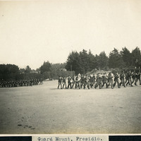
Caption: "Guard Mount. Presidio," c. 1906, shows two groups of men in formation on the Presidio grounds. One group of men is playing musical instruments, while the other group is carrying firearms. Established in 1776 by Spanish explorers, the Presidio is a fortified location overlooking the Golden Gate, the entrance into San Francisco Bay. It was closed as a military structure in 1995, and is now a park within the Golden Gate National Recreation Area.
Date: 1906
-
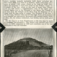
No Caption: A section from an informational tourist brochure describing Teotihuacan, an area northeast of Mexico City and famous for some of the most important archaeological discoveries on the North American Continent.
Date: 1938
-
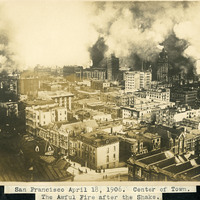
Caption: "San Francisco April 18, 1906. Center of Town. The Awful Fire after the Shake." Fire engulfing buildings in San Francisco's city center after the 1906 earthquake. Great plumes of smoke dominate the photograph. See also 96-07-08-alb02-025.
Date: 4/18/1906