Search All Items
- Filters:
- Type
- Image 3854
- Still Image 1906
- Text 414
- Text 19
- Language
- English 6003
- Spanish 194
- ENGLISH 2
- English 1
- census_013 1
Search Results 2831 to 2840 of 6250
-
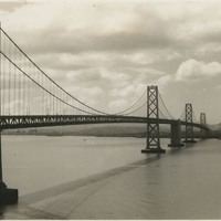
No caption. View of the western, suspension span of the San Francisco-Oakland Bay Bridge, looking toward San Francisco. The photograph was likely taken from a point on either Treasure Island or Yerba Buena Island.
Date: Undated
-
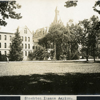
Caption: "Stockton Insane Asylum," c. 1906. The Stockton Insane Asylum was established in 1851, completed in 1853, and was the first public mental health hospital in California. It remained a functioning state hospital until 1995.
Date: 1906
-
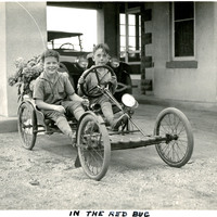
Caption: "In The Red Bug." Two unidentified boys pose in a small go-cart near the carport in front of the John Shields residence, in the Daybreak Estate area of Long Island.
Date: 1934
-
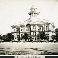
Caption: "Stockton Court House," c. 1906, (E.E. Meyers, Architect). San Joaquin County Courthouse, Stockton, California. The neo-classical building was completed in 1890 and demolished in 1961 to may way for a new courthouse.
Date: Undated
-
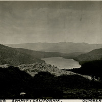
Caption: "Donner Summit, California. October 7, 1934." Panoramic view of Donner Lake and the surrounding mountains. A highway can be glimpsed running through the lower half of the photograph.
Date: 10/7/1934
-
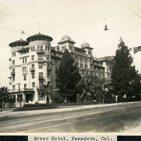
Caption: "Green Hotel, Pasadena, Cal.," c. 1905. View of Castle Green, built as an annex to the Hotel Green in 1899. The original Hotel Green opened for business as a lavish resort in 1894. Its success prompted owner George Gill Green to expand the hotel and build the additional facility shown here, connected to the original hotel by an elaborate enclosed pedestrian bridge (seen at the far right of this photograph). This second building, designed by architect Frederick I. Roehrig with Spanish, Moorish, and Victorian elements, became known as "Castle Green." Business declined in the 1910s, and the complex was sold to a series of investors. In the mid-1920s, Castle Green was subdivided into fifty residential apartments. It remains a residential complex today.
Date: 1905
-
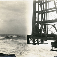
No Caption: See also 96-07-08-alb08-145 with caption: "Pile Driver in the Breakers, Columbia River Jetty," c. 1910. View of a large pile driver used in the construction of the jetty system at the mouth of the Columbia River. This is likely at the end of the so-called South Jetty, extending more than six miles into the ocean from Point Adams on the Oregon side of the river mouth. The jetty system at the mouth of the Columbia River was constructed between 1885 and 1917. Designed to funnel water from the Columbia River in a more concentrated fashion into the Pacific Ocean, the jetty system helped create a deeper, more stable shipping channel.
Date: 1910
-
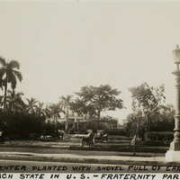
Caption: "Tree in Center Planted with Shovel Full of Earth From Each State in U.S. -- Fraternity Park -- Havana, July 4, 34." This photograph captures a view of Havana's Fraternity Park. The area originally served the city as a military parade and training ground (called Campo de Marte). In 1928, the park was renovated and a ceiba (or kapok) tree was planted in one of the central parcels. This tree, seen in the center of this photograph, was planted as the Tree of American Fraternity. When Havana hosted the sixth International American Conference later in 1928 (also known as one of the Pan-American Conferences), each of the twenty-one visiting dignitaries brought earth from their native counties in which to plant the tree (William McCarthy mistakenly identified the earth as coming from each state in the U.S.).
Date: 7/4/1934
-
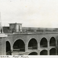
Caption: "Portion of Interior. Fort Point.," c. 1906. View of arched colonnades on ground and middle floors of Fort Point, and an upper tier with barbettes for the future installation of heavy artillery coastal defense weapons. The facilities at Fort Point were part of an effort by the U.S. government to protect the Golden Gate, entrance to the San Francisco Bay. Built between 1853-1861, the fort included emplacements for 141 guns but never fired a weapon in defense of the Bay. Its name was officially changed in 1882 to Fort Winfield Scott, but in 1886 the fort was officially downgraded to a sub-post of the San Francisco Presidio and the name discontinued. It was resurrected in 1912, with the establishment of a coastal artillery fortification at the Presidio, called, once again, Fort Winfield Scott.
Date: 1906
-
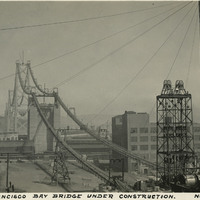
Caption: "San Francisco Bay Bridge Under Construction. Nov. 1, 1935." View of the towers and suspension cables of the western half of the San Francisco-Oakland Bay Bridge, spanning the distance between Yerba Buena Island in San Francisco Bay to the City of San Francisco. The bridge deck has not yet been completed. The Bay Bridge's design combined three different types of bridge-building technology over the five miles it covers between San Francisco and Oakland: a suspension span, a cantilevered span, and a tunnel. At the time of its completion in 1936, the bridge was the longest steel structure on the globe. It also featured the deepest bridge pier ever built, and the world's largest bore tunnel.
Date: 11/1/1935