Search All Items
- Filters:
- Language
- English 3825
- Spanish 4
- ENGLISH 1
- contra_costa_schedule_1_volume_1 1
- Type
- Image 2628
- Still Image 826
- Text 361
- Text 12
- Textual 2
- Image of the California Census from the records of the office of the California Secretary of State 1
Search Results 3441 to 3450 of 3868
-
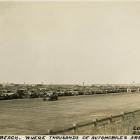
Caption: "Jones's [sic] Beach. Where Thousands of Automobiles are Parked. Long Island, N.Y. Aug. 17, 1934." Photograph of a large parking area full of automobiles on Jones Beach Island. The Long Island State Park Commission began to develop the area for a park in the 1920s, dredging enough sand to connect several of the barrier islands south of Long Island and raising the elevation of the islands by fourteen feet to create one large park. It opened to the public in 1929. It is now a state park, with an estimated six million visitors each year.
Date: 8/17/1934
-
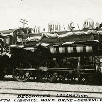
Caption: "Decorated Locomotive. Fifth Liberty Bond Drive -- Benicia, Calif." During World War I, the U.S. government raised funds for the war by issuing "liberty bonds." Citizens who purchased the bonds could later redeem them for the purchase price plus interest. Liberty Bond Drives were held to encourage people to purchase the bonds. This photograph shows a locomotive employed in the fifth Liberty Bond Drive, held in 1919. Decorated with bunting and flags to inspire patriotic feeling, Liberty Bond Trains crisscrossed the U.S. to round up funding.
Date: 1919
-
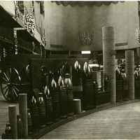
No Caption: See also 96-07-08-alb08-159 with caption: "Government exhibits of shot etc., Government Buidling." Portland Fair, Oregon, 1905. Exhibit of various types of heavy ordnance shells, including armor piercing shells as well as torpedoes. The exhibit was located in the Government Building of the Lewis and Clark Centennial Exposition, held in Portland, Oregon from June 1st to October 15th, 1905. It celebrated the one-hundred year anniversary of the exploratory expedition of the Louisiana Purchase and what became the northwestern part of the United States, led by Meriwether Lewis and William Clark. Some 1.6 million people visited the fair, viewing exhibits from twenty-one countries.
Date: 1905
-
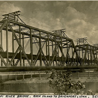
Caption: "Mississippi River Bridge. Rock Island to Davenport, Iowa. Sept. 25, 1934." View of the Government Bridge spanning the Mississippi River between Rock Island and Davenport, Iowa. Built in 1896 and designed by Ralph Modjeski, the bridge in this photograph was the fourth bridge constructed at the site, replacing earlier structures made obsolete by the increasing volume and changing character of traffic. This double-decker bridge connected the U.S. arsenal on Rock Island with Davenport, Iowa, and featured a double rail road track, a separate deck for automobiles, and a swing section. The bridge is still in use today.
Date: 9/25/1934
-
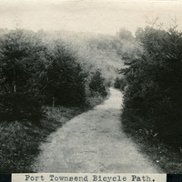
Caption: "Port Townsend Bicycle Path.," c. 1910. Image of a rural path or road, surrounded by trees and vegetation, with a hill in the distance. The bicycle made its first appearance in the Puget Sound area in the late 1870s. Within twenty years, thousands of enthusiasts had adapted the new mode of transportation. Such enthusiasts often formed clubs, such as the Queen City Good Roads Club, based in Seattle (south of Port Townsend). These clubs advocated, constructed, and helped to maintain pathways dedicated specifically to bicycle traffic. Ironically, the efforts made by the bicyclists to generally improve roadways contributed to the rise of another new mode of transportation -- the automobile.
Date: 1910
-
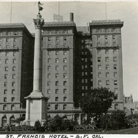
Caption: "St. Francis Hotel - S.F. Cal," c. 1913. St. Francis Hotel at Union Square with partial north wing extension and the Dewey Monument in the foreground (Robert I. Aitken, sculptor), which commemorated U.S. Admiral George Dewey's naval victory at the battle of Manila Bay during the Spanish American War of 1898. The luxury hotel opened in 1904 and, fortunately, suffered little damage from the 1906 earthquake. It was expanded in 1913, and 1972, making it one of the largest hotels in the city. See also 96-07-08-alb01-002.
Date: 1913
-
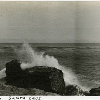
Caption: "Ver De Leu [sic], Santa Cruz," c. 1910. Ocean shore scene with rocks, waves, and high spray. The Vue de L'eau (View of the Water) was a station on the Santa Cruz, Garfield Park and Capitola Electric Railway electric streetcar line. The station, built in 1891, was located at the very end of the line, on a promontory overlooking the Pacific Ocean. It featured an observatory on the top story. The same company also built a casino, ballroom, and restaurant nearby. The station burned down in 1925.
Date: 1910
-
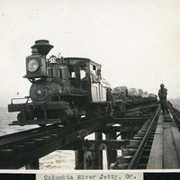
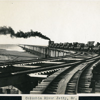
Caption: "Columbia River Jetty, Or.," c. 1910. View of a jetty built at the mouth of the Columbia River, carrying a railroad trestle. A train and its operators, hauling cars loaded with large rocks, dominates the photograph. This is likely the so-called South Jetty, extending more than six miles into the ocean from Point Adams on the Oregon side of the river mouth. The jetty system at the mouth of the Columbia River was constructed between 1885 and 1917. Designed to funnel water from the Columbia River in a more concentrated fashion into the Pacific Ocean, the jetty system helped create a deeper, more stable shipping channel.
Date: 1910
-
Caption: "Columbia River Jetty, Or.," c. 1910. View of a jetty built at the mouth of the Columbia River, carrying a railroad trestle. A train hauling cars loaded with large rocks is steaming away from the photographer. This is likely the so-called South Jetty, extending more than six miles into the ocean from Point Adams on the Oregon side of the river mouth. The jetty system at the mouth of the Columbia River was constructed between 1885 and 1917. Designed to funnel water from the Columbia River in a more concentrated fashion into the Pacific Ocean, the jetty system helped create a deeper, more stable shipping channel.
Date: 1910
-
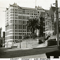
Caption: "Court House - Los Angeles." c. 1915-1920. The Los Angeles County Courthouse, also known as the Red Sandstone Courthouse, was completed in 1891. Located at the southeast corner of Temple and Broadway, the courthouse was damaged beyond repair by the 1933 Long Beach earthquake and demolished in 1936. To the left of the courthouse stands the Hall of Records, built in 1911 and used, along with other buildings, as the county courthouse from 1934 until 1959, when the current courthouse was occupied. The Hall of Records was demolished in 1973.
Date: 1915