Search All Items
- Filters:
- Type
- Image 3607
- Still Image 937
- Text 401
- Text 19
- Image of the California Census from the records of the office of the California Secretary of State 1
- Language
- English 4943
- Spanish 26
- ENGLISH 2
- English 1
- census_013 1
- contra_costa_schedule_1_volume_1 1
Search Results 3571 to 3580 of 5015
-
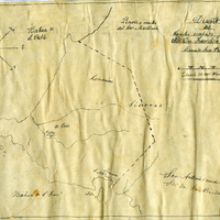
Hand-drawn sketch map of Former lands of Mission Delores, or San Pablo, or Cuchiosmos, or Cuchiguenos, or Cuduyunes boundaries. Volume 1, page 38.
Date: 1834
-
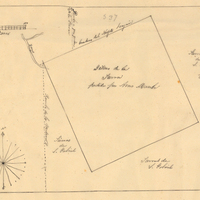
Hand-drawn sketch map of Lot- Mission-San Gabriel boundaries. Volume 2, page 189.
Date: 1843
-
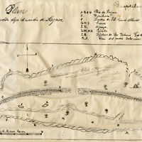
Hand-drawn sketch map of Punta del Monte or Rincon de la Punta del Monte boundaries. Volume 1, page 406.
Date: 1826