Search All Items
- Filters:
- Type
- Image 3609
- Still Image 937
- Text 401
- Text 19
- Image of the California Census from the records of the office of the California Secretary of State 1
- Language
- English 4945
- Spanish 26
- ENGLISH 2
- English 1
- census_013 1
- contra_costa_schedule_1_volume_1 1
Search Results 3581 to 3590 of 5017
-
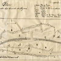
Hand-drawn sketch map of Punta del Monte or Rincon de la Punta del Monte boundaries. Volume 1, page 406.
Date: 1826
-
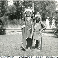
Caption: "Chief Manitou - Manitou Soda Springs," c. 1923. William McCarthy, wearing a Native American headdress and attire, stands next to Pedro Cajete. Mr. Cajete, better known to many as Chief Manitou, was a Native American of the Tewa tribe near Santa Fe, New Mexico, who was hired to promote tourism in the Manitou Springs/Colorado Springs area of Colorado. He often sold trinkets and posed for photographs with tourists near the mouth of Manitou Cave, resulting in his moniker Chief Manitou.
Date: 1923
-
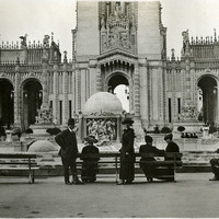
No Caption: William and Grace McCarthy (standing and looking at the camera) at the Panama-Pacific International Exposition, 1915. The Panama Pacific International Exposition was held to celebrate the completion of the Panama Canal, as well as inventive technologies and new industries from around the world. It was also a chance for San Francisco to show the world how the great city had rebuilt and thrived after the devastation of the 1906 earthquake and fire.
Date: 1915