Search All Items
- Filters:
- Type
- Image 1473
- Still Image 304
- Text 72
- Text 19
- Language
- English 1654
- Spanish 215
- ENGLISH 2
- English 1
- census_013 1
Search Results 341 to 350 of 1881
-
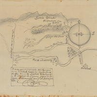
Hand-drawn sketch map of Punta del Monte, or Rincon de la Monte, or Rincon del la Punta de Monte de la Soledad boundaries. Volume 1, page 140.
Date: 1836
-
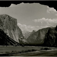
No Caption: In this 1935 photograph, the opening of the Wawona highway tunnel frames the Yosemite Valley with El Capitan (the Captain) on the left, Bridalveil Falls on the right, and Half Dome in the distance.
Date: 1935