Search All Items
- Filters:
- Type
- Image 3639
- Still Image 937
- Text 401
- Text 19
- Image of the California Census from the records of the office of the California Secretary of State 1
- Language
- English 4975
- Spanish 26
- ENGLISH 2
- English 1
- census_013 1
- contra_costa_schedule_1_volume_1 1
Search Results 3731 to 3740 of 5047
-
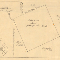
Hand-drawn sketch map of Lot- Mission-San Gabriel boundaries. Volume 2, page 189.
Date: 1843
-
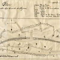
Hand-drawn sketch map of Punta del Monte or Rincon de la Punta del Monte boundaries. Volume 1, page 406.
Date: 1826
-
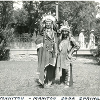
Caption: "Chief Manitou - Manitou Soda Springs," c. 1923. William McCarthy, wearing a Native American headdress and attire, stands next to Pedro Cajete. Mr. Cajete, better known to many as Chief Manitou, was a Native American of the Tewa tribe near Santa Fe, New Mexico, who was hired to promote tourism in the Manitou Springs/Colorado Springs area of Colorado. He often sold trinkets and posed for photographs with tourists near the mouth of Manitou Cave, resulting in his moniker Chief Manitou.
Date: 1923