Search All Items
Search Results 3781 to 3790 of 5331
-
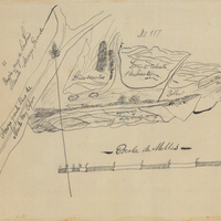
Hand-drawn sketch map of Santa Manuela boundaries. Volume 1, page 258.
Date: 1837
-
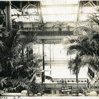
Caption: "Sutro Baths S.F.," c. 1910. Interior shot of the Sutro Baths, north of the Cliff House. Designed by Adolph Sutro in 1894, the bathhouses at one time covered three oceanfront acres just north of Ocean Beach and the Cliff House. Eventually, the Sutro Baths fell into disrepair and what was left of them burned down in 1966. Since 1973, the concrete ruins have been part of the Golden Gate National Recreation Area. See also 96-07-08-alb02-023.
Date: 1910
-
No Caption: See also 96-07-08-alb03-065 with caption: "Fort Casey Lighthouse, Washington," c. 1910. Fort Casey was part of the "triangle of fire," three coastal defense fortifications (Fort Casey, Fort Worden, and Fort Flagler) guarding the entrance to Puget Sound. Construction began on the fort in 1897, and the U.S. Army used the facility until the 1950s, when the fort was decommissioned. The area is now a state park.
Date: 1910
-
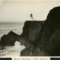
Caption: "Point Benito [sic]. Fort Barry," c. 1910. A view of the Point Bonita Lighthouse near Fort Barry and the Marin Headlands. The lighthouse, built in 1855, was the third lighthouse built on the West Coast to shepherd ships through the narrow straights of the Golden Gate. The lighthouse, still active today, is maintained by the U.S. Coast Guard, and is part of the Golden Gate National Recreation Area.
Date: 1910
-
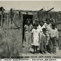
Caption: "Pima Indian Children and their hut made from bush branches, Sacaton Indian Reservation, Sacaton, Arizona," c. 1935. Located south of Phoenix and including the town of Sacaton, the Gila River Indian Reservation is home to members of the Akimel O’odham (Pima) and the Pee-Posh (Maricopa) tribes. The reservation was established in 1859. Eighty years later, in 1939, Congress provided for the self-governance of the reservation via the Gila River Indian Community.
Date: 1935