Search All Items
- Filters:
- Type
- Image 3611
- Still Image 942
- Text 401
- Text 19
- Image of the California Census from the records of the office of the California Secretary of State 1
- Language
- English 4952
- Spanish 26
- ENGLISH 2
- English 1
- census_013 1
- contra_costa_schedule_1_volume_1 1
Search Results 4001 to 4010 of 5024
-
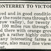
No Caption: A section of a tourist informational brochure describing the road from Monterrey to Victoria.
Date: 1938
-
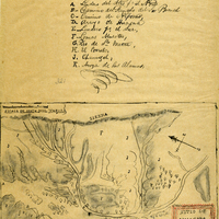
Hand-drawn sketch map of Huasna or Ex-Mission of San Luis Obispo boundaries. Volume 2, page 15.
Date: 1843
-
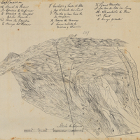
Hand-drawn sketch map of Corral de Piedra boundaries. Volume 1, page 640.
Date: 1839