Search All Items
- Filters:
- Type
- Image 3888
- Still Image 2857
- Text 431
- Text 50
- Image of the California Census from the records of the office of the California Secretary of State 1
- Language
- English 7190
- Spanish 43
- ENGLISH 3
- English 2
- census_013 1
- contra_costa_schedule_1_volume_1 1
Search Results 4631 to 4640 of 7317
-
Image withheld due to copyright considerations. For more information, please contact the California State Archives Reference Desk at ArchivesWeb@sos.ca.gov or (916) 653-2246. Image is a map of the United States showing "Our 1934 United States Automobile Tour. Traveled 10,000 miles -- May 14 to Oct 9.th. Note the Blue Line for Route of Travel." The blue line stretches from San Francisco to Los Angeles, then along the southern portion of the U.S. into Florida, south to Havana, and then north along the East Coast until heading east from Boston. The route skirted the Great Lakes then struck out across the Great Plains, Colorado, and Nevada, before ending in San Francisco to complete the loop.
Date: 1934
-
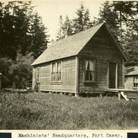
Caption: "Machinists' Headquarters, Fort Casey.," c. 1908-1912. View of building with gabled roof and sides sheathed in wood planks, with a small shed to the left and another small building to the right. Fort Casey was part of the "triangle of fire," three coastal defense fortifications (Fort Casey, Fort Worden, and Fort Flagler) guarding the entrance to Puget Sound. Construction began on the fort in 1897, and the U.S. Army used the facility until the 1950s, when the fort was decommissioned. The area is now a state park.
Date: 1908