Search All Items
- Filters:
- Type
- Image 3785
- Still Image 609
- Text 367
- Text 19
- Image of the California Census from the records of the office of the California Secretary of State 1
- Language
- English 4771
- Spanish 11
- ENGLISH 2
- English 1
- census_013 1
- contra_costa_schedule_1_volume_1 1
Search Results 4741 to 4750 of 4834
-
Resolution passed by County Supervisors Association of California encouraging Japanese to relocate to Japan
Date: June 28-30, 1944; Date of conference where resolution was passed
-
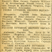
No caption. An undated and unidentified newspaper article titled, "What Ships Make Up the Armada in the Harbor." c.1908. The article describes the forty-three battleships, cruisers, torpedo boats, torpedo boat destroyers, and auxiliary ships in the San Francisco Bay under the Flag of Rear Admiral Evans.
Date: 1908
-
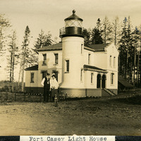
Caption: "Fort Casey Light House [sic]," c. 1905. Located on Whidbey Island in Puget Sound, the Admiralty Head Lighthouse was built overlooking Admiralty Inlet in 1903. It replaced an earlier structure that had to be moved in 1890 to accommodate the construction of Fort Casey. The second lighthouse, shown here, was built with thick walls in order to withstand earthquakes and the concussion of guns at the fort. The man and woman shown in the photograph (standing with a dog) are likely Charles H. Davis and his second wife Delia (Overton) Davis. Charles Davis was appointed keeper of the lighthouse in 1900 and served until his death in 1914. The lighthouse, deactivated in 1922, has since been restored by Washington State Parks, and is part of the Fort Casey State Park. See also 96-07-08-alb02-057.
Date: 1905