Search All Items
- Filters:
- Type
- Image 3854
- Still Image 1906
- Text 414
- Text 19
- Language
- English 6003
- Spanish 194
- ENGLISH 2
- English 1
- census_013 1
Search Results 4881 to 4890 of 6250
-
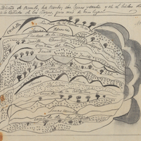
Hand-drawn sketch map of Land in Santa Paula boundaries. Volume 1, page 270.
Date: 1833
-
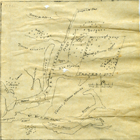
Hand-drawn sketch map of Cañada del Corral boundaries. Volume 1, page 692.
Date: 1840
-
Hand-drawn sketch map of Rio Ojotska or Rio del Sacramento boundaries. Volume 1, page 50.
Date: 1833