Search All Items
- Filters:
- Type
- Image 3851
- Still Image 1032
- Text 431
- Text 19
- Language
- English 5293
- Spanish 43
- ENGLISH 2
- English 1
- census_013 1
Search Results 5001 to 5010 of 5390
-
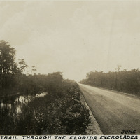
Caption: "Tamiami Trail Through the Florida Everglades, June 27, 1934." Asphalt-paved road stretching into the distance, flanked on one side by a canal. The Tamiami Trail constitutes a scenic portion of what is now U.S. Highway 41. Work on a road connecting Tampa with Miami began in 1915, but the Trail was not officially opened until 1928. Work on the route required building across a portion of the massive swamp system of the Everglades. Workers dredged and blasted a canal along the route, and used the fill dirt thus removed to construct the roadway proper.
Date: 6/27/1934
-
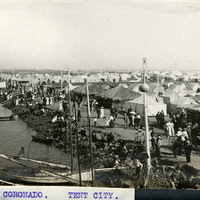
Caption: "CORONADO. TENT CITY.," c. 1910. View of rows of tents and sheds thatched in palm fronds along the coast near Coronado Hotel, with people strolling along the roadways. Established in 1900 for travelers who could not afford to stay in the resort hotel, the Coronado Tent City consisted of a grid of streets lined with furnished tents, near the sea shore. It also featured restaurants, a library, soda fountain, theater, bandstand, and other recreational facilities. See also 96-07-08-alb05-202 and 96-07-08-alb08-263.
Date: 1910
-
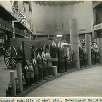
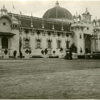
Caption: "Government exhibits of shot etc., Government Building." Exhibit of various types of heavy ordnance shells, including armor piercing shells as well as torpedoes. The exhibit was located in the Government Building of the Lewis and Clark Centennial Exposition, held in Portland, Oregon from June 1st to October 15th, 1905. It celebrated the one-hundred year anniversary of the exploratory expedition of the Louisiana Purchase and what became the northwestern part of the United States, led by Meriwether Lewis and William Clark. Some 1.6 million people visited the fair, viewing exhibits from twenty-one countries. See also 96-07-08-alb05-206.
Date: 1905
-
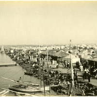
No Caption: c. 1910. View of rows of tents and sheds thatched in palm fronds along the coast near Coronado Hotel, with people strolling along the roadways. Established in 1900 for travelers who could not afford to stay in the resort hotel, the Coronado Tent City consisted of a grid of streets lined with furnished tents, near the sea shore. It also featured restaurants, a library, soda fountain, theater, bandstand, and other recreational facilities. See also 96-07-08-alb05-202 and 96-07-08-alb08-210.
Date: 1910
-
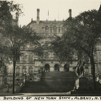
Caption: "Capitol Building of New York State, Albany, N.Y., Sept. 7, 1934." New York State's Capitol Building was constructed between 1867 and 1899. The initial architect, Thomas Fuller, designed the first floor in a Classical or Romanesque style. He was replaced by Leopold Eidlitz and Henry Hobson Richardson, who designed the next two floors in a Renaissance style. The final architect to preside over the project was Isaac G. Perry, who completed the building in a Victorian-Romanesque style. The building was listed on the National Register of Historic Places in 1971, and declared a National Historic Landmark in 1979.
Date: 9/7/1934
-
No Caption: See also 96-07-08-alb08-156 with caption: "Agricultural Building, Portland Fair, 1905." View of the Agriculture and Horticulture Building at the Lewis and Clark Centennial Exposition. The exposition was held in Portland, Oregon from June 1st to October 15th, 1905. It celebrated the one-hundred year anniversary of the exploratory expedition of the Louisiana Purchase and what became the northwestern part of the United States, led by Meriwether Lewis and William Clark. Some 1.6 million people visited the fair, viewing exhibits from twenty-one countries.
Date: 1905
-
Caption: "Little girls who live in Mexico are always fully clothed but, this is not a little girl. OH! OH!" Image of a young boy in a small Mexican village. **PLEASE NOTE: The electronic image derived from Album 10, Photograph 380 of the William McCarthy Photograph Collection (96-07-08-alb10-380) contains content that may not be appropriate for online distribution, and has therefore been withheld. The image has also been removed from the Secretary of State’s digital storage systems, including hard drives, shared drives, cloud and other online storage, and digital backup systems. To view the original photograph, please contact the California State Archives Reference Desk.
Date: 1938
-
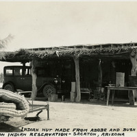
Caption: "Indian Hut Made from Adobe and Bush Branches, Sacaton Indian Reservation - Sacaton, Arizona," c. 1935. View of a small adobe building with a porch area across the length of the façade. The porch is sheltered by a low roof supported by tree trunks or thick tree branches and thatched with grass or sticks. Located south of Phoenix and including the town of Sacaton, the Gila River Indian Reservation is home to members of the Akimel O’odham (Pima) and the Pee-Posh (Maricopa) tribes. The reservation was established in 1859. Eighty years later, in 1939, Congress provided for the self-governance of the reservation via the Gila River Indian Community.
Date: 1935
-
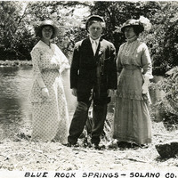
Caption: "Blue Rock Springs -- Solano Co.," c. 1915. Grace McCarthy (far left) and two unidentified friends or relatives at what is now known as Blue Rock Springs. In the 1860s, White Sulphur Springs (in the vicinity of Vallejo) was developed for use as a mineral springs resort, featuring a hotel, several cottages, and an "amusement" building with a dance floor, bar, and billiard room. Manuel Madrid obtained the property around the turn of the twentieth century, and changed the name to Blue Rock Springs. The area is now managed by the Greater Vallejo Recreation District as Blue Rock Springs Park.
Date: 1915
-
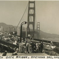
Caption: "Golden Gate Bridge, Opening Day, May 28, 1937." Dozens of automobiles are visible crossing the Golden Gate Bridge in this photograph, taken on the bridge's Opening Day, the first day that vehicular traffic was allowed over the bridge. Completed in 1937, the Golden Gate Bridge spans the mouth of San Francisco Bay (called the Golden Gate), connecting San Francisco with Marin County to the north. It is one of the most recognizable bridges in the world, and was named in 1994 as one of the Modern Wonders of the World by the American Society of Civil Engineers.
Date: 5/28/1937