Search All Items
- Filters:
- Type
- Image 3882
- Still Image 2091
- Text 431
- Text 50
- Image of the California Census from the records of the office of the California Secretary of State 1
- Language
- English 6437
- Spanish 23
- ENGLISH 2
- English 2
- census_013 1
- contra_costa_schedule_1_volume_1 1
Search Results 5401 to 5410 of 6524
-
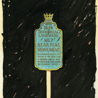
Design study and drawing by Alfred Eichler for Historic Landmark sign for Bear Flag Monument. Project for Department of Natural Resources - Beaches and Parks.
Date: 1947
-
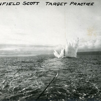
Caption: "Fort Winfield Scott Target Practice." This postcard shows a plume of seawater thrown up by a mortar shell during target practice at Fort Point. Fort Point was part of an effort by the U.S. government to protect the Golden Gate, entrance to the San Francisco Bay. Built between 1853-1861, the fort included emplacements for 141 guns but never fired a weapon in defense of the Bay. Its name was officially changed in 1882 to Fort Winfield Scott. This only lasted four years, however, for in 1886 the fort was officially downgraded to a sub-post of the San Francisco Presidio and the name discontinued. It was resurrected in 1912, with the establishment of a coastal artillery fortification at the Presidio, called, once again, Fort Winfield Scott. See also 96-07-08-alb08-029.
Date: 1909-10-25
-
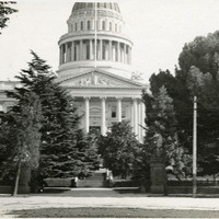
No Caption: The Capitol building in Sacramento, California, c. 1910. Located on the west end of Capitol Park, the neoclassical building's construction began in 1860 and was completed in 1874. It houses the state legislature and offices of the governor. The capitol and grounds were listed on the National Register of Historic Places in 1973, and as a California Historical Landmark in 1974.
Date: 1910
-
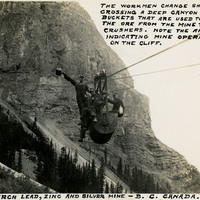
Caption: "The Monarch Lead, Zinc, and Silver Mine - B.C. Canada. The workmen change shifts by crossing a deep canyon in the buckets that are used to transport the ore from the mine to the rock crushers. Note the arrows indicating mine operations on the cliff," c. 1935.
Date: 1935
-
Caption: "#2 -- Record Oct 25, 09." This postcard shows plume of seawater thrown up by a mortar shell during target practice at Fort Point. The facilities at Fort Point were part of an effort by the U.S. government to protect the Golden Gate, entrance to the San Francisco Bay. Built between 1853-1861, the fort included emplacements for 141 guns but never fired a weapon in defense of the Bay. Its name was officially changed in 1882 to Fort Winfield Scott. This only lasted four years, however, for in 1886 the fort was officially downgraded to a sub-post of the San Francisco Presidio and the name discontinued. It was resurrected in 1912, however, with the establishment of a coastal artillery fortification at the Presidio, called, once again, Fort Winfield Scott.
Date: 1909-10-25
-
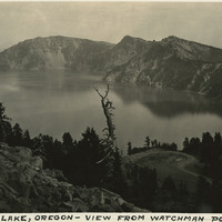
Caption: "Crater Lake, Oregon - View from Watchman Point," c. 1935. Located in the Crater Lake National Park, Crater Lake is a caldera lake formed about 7,700 years ago by the collapse of the volcano, Mount Mazama. Its 1,949 foot depth makes it the deepest lake in the United States.
Date: 1935
-
Preliminary design drawing by Alfred Eichler of M Street Bridge Machinery House; the drawing, dated February 9, 1934, is labeled "superseded." The Tower Bridge replaced the M Street Bridge, which was removed in 1935. Project for Department of Public Works - Highways - Bridge Department.
Date: 1934
-
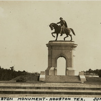
Caption: "Sam Houston Monument -- Houston Tex. June 8, 34." View of the San Houston Monument, a twenty-foot-tall bronze sculpture designed by Enrico Cerracchio and dedicated in 1925. The sculpture commemorates Sam Houston, a prominent soldier and politician who served as the first and third President of the Republic of Texas before its annexation to the U.S. Houston also served as Governor of Texas and as a U.S. Senator for both Texas and Tennessee.
Date: 6/8/1934
-
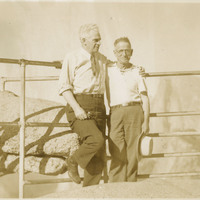
No Caption: William McCarthy (right) and an unidentified man at Yosemite National Park, c. 1935.
Date: 1935
-
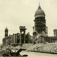
No Caption: The San Francisco City Hall in ruins after the 1906 earthquake and resulting fires.
Date: 1906