Search All Items
- Filters:
- Type
- Image 3877
- Still Image 1470
- Text 425
- Text 50
- Image of the California Census from the records of the office of the California Secretary of State 1
- Language
- English 5791
- Spanish 37
- ENGLISH 2
- English 2
- census_013 1
- contra_costa_schedule_1_volume_1 1
Search Results 5491 to 5500 of 5886
-
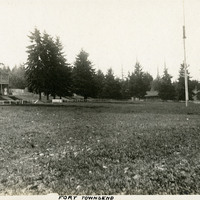
Caption: "Fort Townsend," c. 1906. Park-like scene, with buildings in the distance and a flag pole at the right. The U.S. Army established Fort Townsend in 1856. Abandoned after a fire destroyed the barracks buildings in 1895, it was reactivated during World War II to serve as a munitions defusing station. It was turned over to the State of Washington in 1953, and is now in use as Fort Townsend State Park.
Date: 1906
-
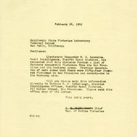
Correspondence from S. H. Dado to California State Fisheries Laboratory requesting list of Japanese holders of commercial fishing licenses
Date: February 24, 1942
-
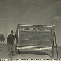
Caption: "State Sign, Between Rawlins and Rock Springs, Wyoming. Oct. 1, 1934." William McCarthy standing next to an informational road sign in Wyoming, noting the location as being along the U.S.'s primary Continental Divide.
Date: 10/1/1934
-
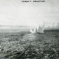
Caption: "Target Practice," c. 1908. This postcard shows a plume of seawater thrown up by a mortar shell during target practice at Fort Point. The facilities at Fort Point were part of an effort by the U.S. government to protect the Golden Gate, entrance to the San Francisco Bay. Built between 1853-1861, the fort included emplacements for 141 guns but never fired a weapon in defense of the Bay. Its name was officially changed in 1882 to Fort Winfield Scott, but in 1886 the fort was officially downgraded to a sub-post of the San Francisco Presidio and the name discontinued. It was resurrected in 1912, with the establishment of a coastal artillery fortification at the Presidio, called, once again, Fort Winfield Scott. See also 96-07-08-alb05-322.
Date: 1908
-
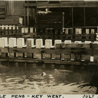
Caption: "Turtle Pens -- Key West. July 2, 1934." View of turtle kraals, or turtle corrals, used in the turtle fishing industry in Key West. Green turtles were kept in these pens prior to slaughter or transport. Turtle meat and eggs were popular food items in the early-to-mid twentieth century; turtle fat was especially prized for making turtle soup. However, the turtle population plummeted in the Florida Keys and surrounding areas as the twentieth century progressed and demand increased. The turtle kraals and nearby canneries closed when the Endangered Species Act was passed in 1971. Populations have since started to recover. The cannery near the kraals shown in this photograph now serves as the Key West Turtle Museum.
Date: 7/2/1934