Search All Items
- Filters:
- Language
- English 5811
- Spanish 37
- ENGLISH 2
- English 2
- census_013 1
- contra_costa_schedule_1_volume_1 1
- Type
- Image 3877
- Still Image 1473
- Text 439
- Text 54
- Textual 2
- Image of the California Census from the records of the office of the California Secretary of State 1
Search Results 5561 to 5570 of 5921
-
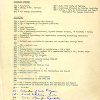
List of bulletins and circular letters relating to procedures published and distributed to counties
Date: Undated
-
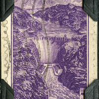
No Caption: A 1935 three-cent U.S. Postage stamp, featuring Boulder Dam, now known as Hoover Dam, which was constructed between 1931 and 1936. The concrete arch-gravity dam is located in the Black Canyon of the Colorado River on the border between Clark County, Nevada, and Mojave County, Arizona. A National Historic Landmark, the dam provides hydroelectric power, water storage, flood control, and recreation at Lake Mead, the reservoir created by the dam's construction.
Date: 1935
-
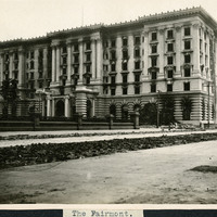
Caption: "The Fairmont," c. 1906. View of the Fairmont Hotel, a luxury hotel in San Francisco. Although construction was mostly finished in 1906, the advent of the San Francisco earthquake and fire of that year damaged the hotel's interior and delayed opening until 1907. It was the first hotel in what is now the Fairmont Hotels and Resorts chain. In 1945, the San Francisco hotel was host to an international conference that culminated in the formation of the United Nations.
Date: 1906
-
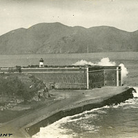
Caption: "Fort Point," c. 1910. This postcard shows a view of Fort Point, at the entrance to San Francisco Bay. The facilities at Fort Point were part of an effort by the U.S. government to protect the Golden Gate, entrance to the San Francisco Bay. Built between 1853-1861, the fort included emplacements for 141 guns but never fired a weapon in defense of the Bay. Its name was officially changed in 1882 to Fort Winfield Scott, but in 1886 the fort was officially downgraded to a sub-post of the San Francisco Presidio and the name discontinued. It was resurrected in 1912, with the establishment of a coastal artillery fortification at the Presidio, called, once again, Fort Winfield Scott.
Date: 1910
-
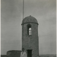
Caption: "Fort Marion, St. Augustine, Fla. July 10, 1934." William McCarthy standing in front of a corner tower on the ramparts of Castillo de San Marcos (Castle of Saint Mark). The core structures of this coastal defense fort were completed by Spanish forces in 1695. Numerous additions, renovations, and repairs have occurred since that time. When Spain ceded Florida to the U.S. in 1821, the Castillo was designated a U.S. Army base and renamed Fort Marion, in honor of Frances Marion (also known as the Swamp Fox, Marion was an American Revolutionary War hero known for his guerilla war tactics). The fort was deactivated in 1933, and turned over to the National Park Service.
Date: 7/10/1934
-
Caption: "Prado or Promenade -- Havana -- Cub. July 4, 1934." Street scene, with a wide street lined with marble benches and trees on both sides. The Paseo del Prado is the oldest paved street in Havana, marking the line between Centro Habana and Old Havana. Its route was established in 1772 by Don Felipe Fonsdeviela y Ondeano. The street was redesigned in 1925 by landscape architect Jean-Claude Nicolas Forestier (who added the trees and marble benches).
Date: 7/4/1934
-
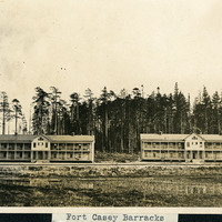
Caption: "Fort Casey Barracks," c. 1908-1912. View of two barracks buildings at Fort Casey, located on Whidbey Island in Puget Sound. Construction began on the fort in 1897. Fort Casey was part of the "triangle of fire," three coastal defense fortifications (Fort Casey, Fort Worden, and Fort Flagler) guarding the entrance to Puget Sound. The U.S. Army used the facility until the 1950s, when the fort was decommissioned. The area is now a state park.
Date: 1908
-
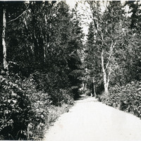
No Caption: See also 96-07-08-alb08-024 with caption: Ordnance Avenue, Fort Casey," Washington, c. 1908. Fort Casey was part of the "triangle of fire," three coastal defense fortifications (Fort Casey, Fort Worden, and Fort Flagler) guarding the entrance to Puget Sound. Construction began on the fort in 1897, and the U.S. Army used the facility until the 1950s, when the fort was decommissioned. The area is now a state park.
Date: 1908
-
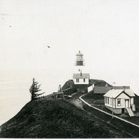
No Caption: See also 96-07-08-alb08-153 with caption: "Fort Canby Light House, Wash." c. 1910. View of the Cape Disappointment Lighthouse on a rocky point overlooking the mouth of the Columbia River. Cannons and cannon balls are stored on the lighthouse property. Built in the 1850s, the lighthouse was electrified in 1934 and automated in 1973. The lighthouse is now part of the Cape Disappointment State Park (formerly Fort Canby State Park).
Date: 1910