Search All Items
- Filters:
- Type
- Image 3877
- Still Image 1470
- Text 425
- Text 50
- Image of the California Census from the records of the office of the California Secretary of State 1
- Language
- English 5791
- Spanish 37
- ENGLISH 2
- English 2
- census_013 1
- contra_costa_schedule_1_volume_1 1
Search Results 5741 to 5750 of 5886
-
Written statement arguing in opposition of AB2710
Date: February 22, 1982
-
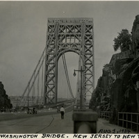
Caption: "George Washington Bridge. New Jersey to New York. Aug 1, 1934." This suspension bridge, designed by Othmar Ammann, spans the Hudson River between Manhattan in New York City, and Fort Lee, New Jersey. Constructed between 1927 and 1931, the bridge included the longest main span in the world at the time, a record it held until construction of the Golden Gate Bridge was completed in 1937. It was originally built with only one deck, but a second deck opened in 1962. Still in active use today, it carried over 51 million vehicles in 2016.
Date: 8/1/1934
-
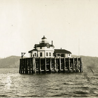
No Caption: c. 1910. View of the Desdemona Lighthouse, constructed in 1901 or 1902 on wood pilings over a group of shoals at the mouth of the Columbia River. The shoals carry the same name as the lighthouse, both of which are named for the bark Desdemona which ran aground and was destroyed by the shoals in 1857. The lighthouse was automated in 1934, and its light eventually removed in 1965.
Date: 1910
-
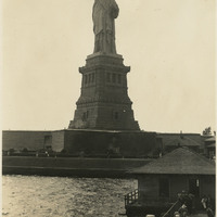
Caption: "Statue of Liberty, New York." View of the Statue of Liberty on Bedloe Island (now called Liberty Island). Designed by French sculptor Frédéric Auguste Bartholdi, the now-iconic statue was a gift from the people of France to the U.S. Built in segments in France by Gustave Eiffel (also famous for building the Eiffel Tower in Paris), the pieces were shipped from Paris to New York in 1885 and assembled. The Statue of Liberty was subsequently dedicated on October 28, 1886.
Date: 1934
-
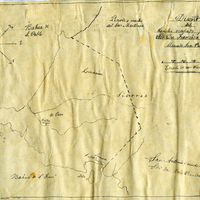
Hand-drawn sketch map of Former lands of Mission Delores, or San Pablo, or Cuchiosmos, or Cuchiguenos, or Cuduyunes boundaries. Volume 1, page 38.
Date: 1834
-
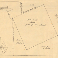
Hand-drawn sketch map of Lot- Mission-San Gabriel boundaries. Volume 2, page 189.
Date: 1843
-
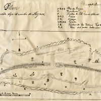
Hand-drawn sketch map of Punta del Monte or Rincon de la Punta del Monte boundaries. Volume 1, page 406.
Date: 1826
-
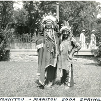
Caption: "Chief Manitou - Manitou Soda Springs," c. 1923. William McCarthy, wearing a Native American headdress and attire, stands next to Pedro Cajete. Mr. Cajete, better known to many as Chief Manitou, was a Native American of the Tewa tribe near Santa Fe, New Mexico, who was hired to promote tourism in the Manitou Springs/Colorado Springs area of Colorado. He often sold trinkets and posed for photographs with tourists near the mouth of Manitou Cave, resulting in his moniker Chief Manitou.
Date: 1923