Search All Items
- Filters:
- Type
- Image 3871
- Still Image 1541
- Text 433
- Text 19
- Image of the California Census from the records of the office of the California Secretary of State 1
- Language
- English 5808
- Spanish 62
- ENGLISH 2
- English 1
- census_013 1
- contra_costa_schedule_1_volume_1 1
Search Results 5741 to 5750 of 5932
-
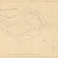
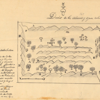
Hand-drawn sketch map of Cañada de los Osos y Pecho y Islae boundaries. Volume 2, page 143.
Date: 1843
-
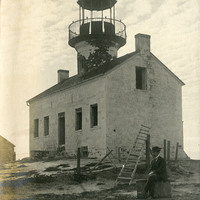
No Caption: View of the dilapidated Old Point Loma Lighthouse. An unidentified man sits in front of it. Lighted for the first time in 1855, this lighthouse sat on a high cliff above Point Loma near San Diego. Unfortunately, its high elevation resulted in fog or low-lying clouds often obscuring the light. The lighthouse was replaced by a new facility (Point Loma Light -- see 96-07-08-alb08-211 and 226) in 1891. The old lighthouse deteriorated over the years, until being restored in the early 1930s. It is now a museum.
Date: 1905
-
Hand-drawn sketch map of Alamos y Agua Caliente boundaries. Volume 2, page 199.
Date: 1845