Search All Items
- Filters:
- Language
- English 5827
- Spanish 62
- ENGLISH 2
- English 1
- census_013 1
- contra_costa_schedule_1_volume_1 1
- Type
- Image 3871
- Still Image 1544
- Text 447
- Text 22
- Textual 2
- Image of the California Census from the records of the office of the California Secretary of State 1
Search Results 5841 to 5850 of 5968
-
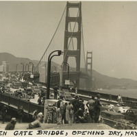
Caption: "Golden Gate Bridge, Opening Day, May 28, 1937." Dozens of automobiles are visible crossing the Golden Gate Bridge in this photograph, taken on the bridge's Opening Day, the first day that vehicular traffic was allowed over the bridge. Completed in 1937, the Golden Gate Bridge spans the mouth of San Francisco Bay (called the Golden Gate), connecting San Francisco with Marin County to the north. It is one of the most recognizable bridges in the world, and was named in 1994 as one of the Modern Wonders of the World by the American Society of Civil Engineers.
Date: 5/28/1937
-
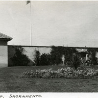
Caption: "Sutter [sic] Fort. Sacramento.," c. 1920. A gun tower at Sutter's Fort, and a gate bracketed by two cannons. John Sutter established the fort in 1839, calling it New Helvetia. After the discovery of gold at one of Sutter's mills (at Coloma, on the American River), almost all of the fort's inhabitants left for the gold fields in the foothills. The fort deteriorated until being restored from 1891-1893. The fort is now the site of a State Historic Park. See also 96-07-08-alb05-118.
Date: 1920
-
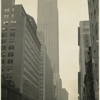
Caption: "Empire State Bldg. 1250 Ft. High, 102 Stories. 34th St. New York. Aug. 13, 1934." View from the sidewalk, looking up at the Empire State Building. Construction began on this iconic 102-story building, designed by William F. Lamb, in 1930. Completed by early 1931, it held the title of world's tallest building for almost 40 years, until being surpassed in 1970 by the construction of the World Trade Center's North Tower. It is now the fifth-tallest building in the U.S., and the 28th-tallest in the world.
Date: 8/13/1934
-
Caption: "Hialeah Race Track -- Miami -- Florida July 1, 1934." Grace McCarthy standing behind the grandstand at Hialeah Park Race Track, in Hialeah (near Miami). Constructed in 1922 as a greyhound racetrack, Hialeah began hosting horse races in 1925. Joseph E. Widener purchased the track in 1930. He embarked upon a series of improvements, adding a grandstand (seen here) and clubhouse facilities designed by Lester W. Geisler, as well as landscaped gardens and a lake in the infield that became home to a flock of flamingos. The new and improved Hialeah track, now called Hialeah Park, officially opened in 1932.
Date: 7/1/1934
-
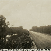
Caption: "Tamiami Trail Through the Florida Everglades, June 27, 1934." Asphalt-paved road stretching into the distance, flanked on one side by a canal. The Tamiami Trail constitutes a scenic portion of what is now U.S. Highway 41. Work on a road connecting Tampa with Miami began in 1915, but the Trail was not officially opened until 1928. Work on the route required building across a portion of the massive swamp system of the Everglades. Workers dredged and blasted a canal along the route, and used the fill dirt thus removed to construct the roadway proper.
Date: 6/27/1934
-
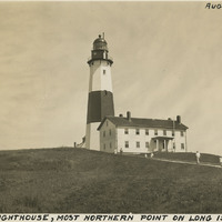
Caption: "Montauk Lighthouse, Most Northern Point on Long Island, N.Y., Aug. 18, 1934." The Montauk Lighthouse, first lit in 1797, was the first lighthouse built in New York. Ezra L'Hommedieu designed the building as well as choosing its site on the eastern edge of Long Island. A renovation in 1860 raised the lighthouse to its current height of more than 110 feet. A larger lantern was installed at that time as well. Electrified in 1940, it is now a National Historic Landmark as well as an active lighthouse.
Date: 8/18/1934
-
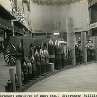
Caption: "Government exhibits of shot etc., Government Building." Exhibit of various types of heavy ordnance shells, including armor piercing shells as well as torpedoes. The exhibit was located in the Government Building of the Lewis and Clark Centennial Exposition, held in Portland, Oregon from June 1st to October 15th, 1905. It celebrated the one-hundred year anniversary of the exploratory expedition of the Louisiana Purchase and what became the northwestern part of the United States, led by Meriwether Lewis and William Clark. Some 1.6 million people visited the fair, viewing exhibits from twenty-one countries. See also 96-07-08-alb05-206.
Date: 1905
-
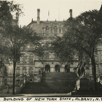
Caption: "Capitol Building of New York State, Albany, N.Y., Sept. 7, 1934." New York State's Capitol Building was constructed between 1867 and 1899. The initial architect, Thomas Fuller, designed the first floor in a Classical or Romanesque style. He was replaced by Leopold Eidlitz and Henry Hobson Richardson, who designed the next two floors in a Renaissance style. The final architect to preside over the project was Isaac G. Perry, who completed the building in a Victorian-Romanesque style. The building was listed on the National Register of Historic Places in 1971, and declared a National Historic Landmark in 1979.
Date: 9/7/1934
-
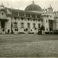
No Caption: See also 96-07-08-alb08-156 with caption: "Agricultural Building, Portland Fair, 1905." View of the Agriculture and Horticulture Building at the Lewis and Clark Centennial Exposition. The exposition was held in Portland, Oregon from June 1st to October 15th, 1905. It celebrated the one-hundred year anniversary of the exploratory expedition of the Louisiana Purchase and what became the northwestern part of the United States, led by Meriwether Lewis and William Clark. Some 1.6 million people visited the fair, viewing exhibits from twenty-one countries.
Date: 1905