Search All Items
- Filters:
- Type
- Image 3854
- Still Image 1906
- Text 414
- Text 19
- Language
- English 6003
- Spanish 194
- ENGLISH 2
- English 1
- census_013 1
Search Results 5861 to 5870 of 6261
-
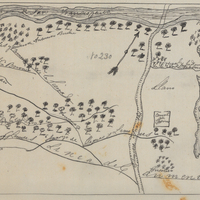
Hand-drawn sketch map of Rincon de San Francisquito boundaries. Volume 1, page 624.
Date: 1841
-
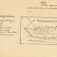
Hand-drawn sketch map of Cañada de San Miguelito or Cañada del Diablo boundaries. Volume 2, page 167.
Date: 1845