Search All Items
- Filters:
- Type
- Image 3877
- Still Image 1470
- Text 425
- Text 50
- Image of the California Census from the records of the office of the California Secretary of State 1
- Language
- English 5791
- Spanish 37
- ENGLISH 2
- English 2
- census_013 1
- contra_costa_schedule_1_volume_1 1
Search Results 5871 to 5880 of 5886
-
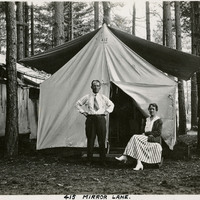
Caption: "Mirror Lane - Camp Curry," c. 1917. William and Grace McCarthy pose in front of their tent at what was then called Camp Curry. Yosemite's Half Dome Village, established by David and Jennie Curry in 1899, was originally called Camp Curry, and then later Curry Village. It was designed to provide cheaper accommodations for Yosemite tourists than the resort hotels. The couple rented out furnished tents and provided amenities such as a dining tent. As time progressed, the amenities increased, and some hard-sided cabins created.
Date: 1917
-
A series of short notations about hospital patients under the supervision of Dr. Reid. Volumes one through four in this series run chronologically, starting in 1852 and ending in 1856. The entries include details such as patient name, nationality, and age, as well as mental disposition. A researcher with an interest in a particular hospital patient may find Reidà¿s journals useful. Dr. Robert K. Reid's medical journals do not include private thoughts about the medical profession or details about Reid's role as a physician at Stockton State Hospital. The fifth volume in the series contains Dr. Reid's Meteorological Observations. Beginning in 1850, Reid recorded daily meteorological observations, including three daily temperature recordings, taken at 8 a.m., 2 p.m., and 8 p.m.. He also recorded cloud, wind, and rain observations, and in 1853, began recording daily barometric pressures. Dr. Robert K. Reid's Meteorological Observations journal continues through 1856.
Date: 1850-1856
-
Correspondence from K. C. May to S. H. Thompson regarding food stamp policy; Attached to Correspondence on Policy Ruling (F3729_66_005)
Date: August 14, 1942
-
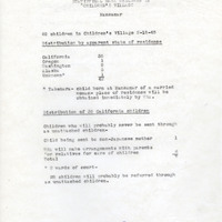
Statistics on number and ages of children in the Manzanar Children's Village
Date: February 15, 1945
-
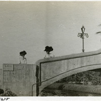
Caption: "Venice, Calif," c. 1911. Grace McCarthy and an unidentified woman standing on a bridge over Lion Canal in Venice, California. In 1905, Abbot Kinney built a series of canals as part of a development project along Santa Monica Beach, hoping to recreate the look and feel of Italy's iconic "Floating City" in southern California. Called Ocean Park at first, gondoliers sailed boats under elegant bridges such as the one shown in this photograph, in an effort to attract businesses, residents, and investors. In 1911, the name officially changed to Venice. By 1929, however, many of the canals had been filled in to create roadways, and those canals that remained fell into disrepair. A revitalization movement in the early 1990s has restored some of the canals, and made the area a desirable residential neighborhood.
Date: 1911
-
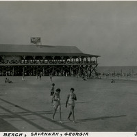
Caption: "Tybee Beach, Savannah, Georgia, July 14, 1934." Beach scene with a small crowd of unidentified people enjoying the ocean waves and strolling in the sand. The large Tybrisa Pavilion, set on a wood pier, extends into the water. Tybee Beach is one of several beaches in Tybee Island, a town on an island of the same name located across the river from Savannah. The island became a popular tourist spot between the Civil War and the mid-twentieth century, particularly after the Central of Georgia Railway constructed a line to the island. To encourage tourists, the railroad built Tybrisa Pavilion in 1891. It featured a large dance floor that became popular on the Big Band circuit, but was destroyed by fire in 1967.
Date: 7/14/1934
-
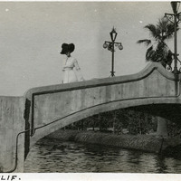
Caption: "Venice, Calif," c. 1911. Unidentified woman standing on a bridge over Lion Canal in Venice, California. In 1905, Abbot Kinney built a series of canals as part of a development project along Santa Monica Beach, hoping to recreate the look and feel of Italy's iconic "Floating City" in southern California. Called Ocean Park at first, gondoliers sailed boats under elegant bridges such as the one shown in this photograph, in an effort to attract businesses, residents, and investors. In 1911, the name officially changed to Venice. By 1929, however, many of the canals had been filled in to create roadways, and those canals that remained fell into disrepair. A revitalization movement in the early 1990s has restored some of the canals, and made the area a desirable residential neighborhood.
Date: 1911
-
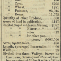
Closeup on Monterey County from image of a page from the newspaper Placer Times reporting the Census of 1852 returns.
Date: 1853
-
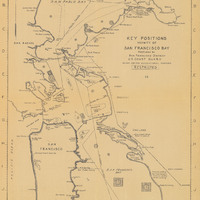
Map of San Francisco Bay indicating positions of key locations in the vicinity' Prepared by San Francisco District U. S. Coast Guard
Date: Undated