Search All Items
- Filters:
- Type
- Image 3871
- Still Image 1541
- Text 433
- Text 19
- Image of the California Census from the records of the office of the California Secretary of State 1
- Language
- English 5808
- Spanish 62
- ENGLISH 2
- English 1
- census_013 1
- contra_costa_schedule_1_volume_1 1
Search Results 5891 to 5900 of 5946
-
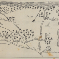
Hand-drawn sketch map of Ausaymas y San Felipe boundaries. Volume 1, page 362.
Date: 1833
-
Caption: "Columbia River Jetty, Or.," c. 1910. View of a jetty built at the mouth of the Columbia River, carrying a railroad trestle. A train hauling cars loaded with large rocks is visible at the left side of the photograph. This is likely the so-called South Jetty, extending more than six miles into the ocean from Point Adams on the Oregon side of the river mouth. The jetty system at the mouth of the Columbia River was constructed between 1885 and 1917. Designed to funnel water from the Columbia River in a more concentrated fashion into the Pacific Ocean, the jetty system helped create a deeper, more stable shipping channel.
Date: 1910
-
Caption: "Government exhibits of clothing, Government Building." This exhibit demonstrates a variety of military uniforms, displayed on mannequins. It was located in the Government Building of the Lewis and Clark Centennial Exposition, held in Portland, Oregon from June 1st to October 15th, 1905. It celebrated the one-hundred year anniversary of the exploratory expedition of the Louisiana Purchase and what became the northwestern part of the United States, led by Meriwether Lewis and William Clark. Some 1.6 million people visited the fair, viewing exhibits from twenty-one countries.
Date: 1905
-
Caption: "Golden Gate Bridge, Construction, July 1, 1936." Image of one terminus of the Golden Gate Bridge, showing the anchoring site of the suspension wires. Completed in 1937, the Golden Gate Bridge spans the mouth of San Francisco Bay (called the Golden Gate), connecting San Francisco with Marin County to the north. It is one of the most recognizable bridges in the world, and was named in 1994 as one of the Modern Wonders of the World by the American Society of Civil Engineers.
Date: 7/1/1936
-
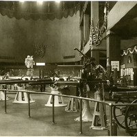
Caption: "Government exhibits of navy guns, Government Building." Shows a variety of naval weaponry. The exhibit was located in the Government Building of the Lewis and Clark Centennial Exposition, held in Portland, Oregon from June 1st to October 15th, 1905. The exposition celebrated the one-hundred year anniversary of the exploratory expedition of the Louisiana Purchase and what became the northwestern part of the United States, led by Meriwether Lewis and William Clark. Some 1.6 million people visited the fair, viewing exhibits from twenty-one countries.
Date: 1905
-
Caption: "Yosemite Falls - View From Ledge Trail," c. 1917. Yosemite Falls in the distance, as seen from across the valley on the Ledge Trail above Half Dome Village. The highest waterfall in Yosemite National Park, Yosemite Falls is made up of two successive cascades falling a total of 2,425 feet from the top of the Upper Fall to the base of the Lower Fall. The Upper Fall alone is 1,430 feet high, and is one of the top twenty highest waterfalls in the world.
Date: 1917