Search All Items
- Filters:
- Type
- Image 3854
- Still Image 1906
- Text 414
- Text 19
- Language
- English 6003
- Spanish 194
- ENGLISH 2
- English 1
- census_013 1
Search Results 5921 to 5930 of 6261
-
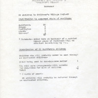
Statistics on number and ages of children in the Manzanar Children's Village
Date: February 15, 1945
-
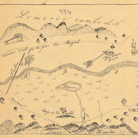
Hand-drawn sketch map of Santa Iasabel boundaries. Volume 2, page 81.
Date: 1843
-
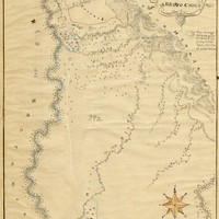
Hand-drawn sketch map of Santa Monica Boca, or San Vicente y Santa Monica boundaries. Volume 2, page 49.
Date: 1836