Search All Items
- Filters:
- Type
- Image 3882
- Still Image 2127
- Text 433
- Text 50
- Image of the California Census from the records of the office of the California Secretary of State 1
- Language
- English 6465
- Spanish 33
- ENGLISH 2
- English 2
- census_013 1
- contra_costa_schedule_1_volume_1 1
Search Results 6071 to 6080 of 6569
-
No Caption: See also 96-07-08-alb08-139 with caption: "Fort Stevens, Or," c. 1910. A view of buildings at Fort Stevens, part of the Three Fort Harbor Defense System protecting the mouth of the Columbia River from enemy incursion or attack (the other forts being Fort Columbia and Fort Canby, both in Washington). Built during the Civil War, the fort remained active until after World War II. In June 1942, Fort Stevens gained the dubious distinction of being the only military installation in the continental United States to come under enemy fire when a Japanese submarine surfaced off the coast and fired seventeen missiles at the fort. The missiles destroyed the backstop to the fort's baseball field, but otherwise did little harm. Fort Stevens was decommissioned in 1947. It was later turned over to the Oregon Parks and Recreation Department, and currently is the site of an Oregon State Park.
Date: 1910
-
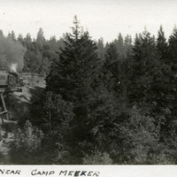
Caption: "Scenery Near Camp Meeker," c. 1906. Train crossing trestle at left side of photograph, with trees and other vegetation occupying most of the photograph's area. Camp Meeker, in Sonoma County north of San Francisco, is in the California Coast Ranges. Established by lumber baron Melvin Cyrus Meeker in 1866, by the turn of the twentieth century the area primarily served as a vacation and resort destination.
Date: 1906
-
No Caption: See also 96-07-08-alb03-065 with caption: "Fort Casey Lighthouse, Washington," c. 1910. Fort Casey was part of the "triangle of fire," three coastal defense fortifications (Fort Casey, Fort Worden, and Fort Flagler) guarding the entrance to Puget Sound. Construction began on the fort in 1897, and the U.S. Army used the facility until the 1950s, when the fort was decommissioned. The area is now a state park.
Date: 1910
-
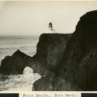
Caption: "Point Benito [sic]. Fort Barry," c. 1910. A view of the Point Bonita Lighthouse near Fort Barry and the Marin Headlands. The lighthouse, built in 1855, was the third lighthouse built on the West Coast to shepherd ships through the narrow straights of the Golden Gate. The lighthouse, still active today, is maintained by the U.S. Coast Guard, and is part of the Golden Gate National Recreation Area.
Date: 1910
-
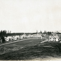
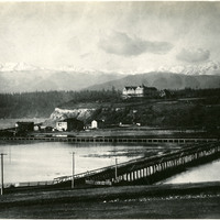
No Caption: See also 96-07-08-alb08-082 with caption: "The Olympic Snow-capped Mountains," Washington, c. 1908. Vista of the Olympic Mountains in the distance. In the middle distance to the right can be seen the Eisenbeis Castle (now known as the Manresa Castle Restaurant and Lounge), built in 1892 by Charles Eisenbeis, a businessman and Port Townsend's first mayor. The photograph is centered around what appears to be a resort hotel situated a short distance from the Eisenbeis Castle.
Date: 1908
-
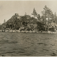
No Caption: c. 1935. Fannette Island is located in Emerald Bay, on the west shore of Lake Tahoe. In 1928, Mrs. Lora Josephine Knight purchased the property encompassing the head of Emerald Bay and Fannette Island. Knight had a summer home built in Scandinavian architectural style and called it Vikingsholm. The stone structure at the top of Fannette island is the "Tea House," built in 1928-1929, at the same time Vikingsholm was built.
Date: 1935
-
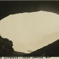
Caption: "Carlsbad Caverns -- Inside Looking Out, May, 30, 34." View looking out of the mouth of Carlsbad Cavern, a series of natural underground chambers including the "Big Room," the fifth-largest such chamber in North America with a length of 1,000 feet, a width of 625 feet, and a maximum height of 255 feet. The site was named Carlsbad Cave National Monument in 1923, and declared Carlsbad Caverns National Park in 1930.
Date: 5/30/1934
-
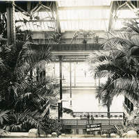
No Caption: Interior shot of the Sutro Baths, north of the Cliff House, c. 1910. Designed by Adolph Sutro in 1894, the bathhouses at one time covered three oceanfront acres just north of Ocean Beach and the Cliff House. Eventually, the Sutro Baths fell into disrepair and what was left of them burned down in 1966. Since 1973, the concrete ruins have been part of the Golden Gate National Recreation Area.
Date: 1910