Search All Items
- Filters:
- Type
- Image 3872
- Still Image 1847
- Text 428
- Text 50
- Image of the California Census from the records of the office of the California Secretary of State 1
- Language
- English 6191
- Spanish 11
- ENGLISH 2
- English 2
- census_013 1
- contra_costa_schedule_1_volume_1 1
Search Results 6161 to 6170 of 6265
-
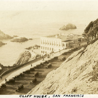
Caption: "Cliff House, San Francisco," c. 1920. The building shown here is the fourth iteration of the Cliff House, a neo-classical design built after a fire destroyed the Victorian structure previously at the site in 1907. Reconstruction of the iconic restaurant began in 1908, and a new Cliff House opened in 1909 (the building in this photograph). The building was extensively remodeled in the 1930s.
Date: 1920
-
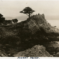
Caption: "Midway Point.," c. 1920. Now-iconic image of a rocky outcropping near Pebble Beach, extending into the Pacific Ocean, with a single cypress tree near the top. This tree, sometimes referred to as the "Lone Cypress," has been photographed extensively over the past century. This tree and outcropping can still be seen as part of the 17-Mile Drive, a scenic road tour of the Pebble Beach Resort area in Monterey County.
Date: 1920
-
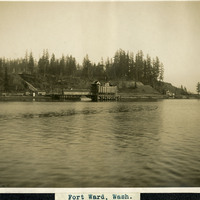
Caption: "Fort Ward, Wash.," c. 1908-1912. View from Puget Sound of a wharf and other buildings of Fort Ward. Originally known as Bean Point, Fort Ward was established by the U.S. Army Coastal Artillery Corps in 1890. Re-named Fort Ward in 1903, the facility included four coastal batteries designed to assist in protecting Puget Sound and the nearby Naval Shipyard from enemy attack. Fort Ward was placed on inactive status in the 1920s, but was revived by the U.S. Navy during World War II. The Navy discovered the fort's location was ideal for listening to radio communications from Japan, and it subsequently became a top secret listening post with a link directly to Washington, D.C. The Navy continued the fort's use as a listening post until 1956, when it was again taken over by the U.S. Army. The Army subsequently stopped all activity in 1958, ultimately selling portions of the fort to the Washington State Park System in 1960. It is now a state park.
Date: 1908
-
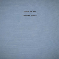
The Census of 1852 collection includes enumerations of California's 32 counties, arranged into 126 volumes. Schedule I enumerated the county's inhabitants, while schedule II enurmerated economic production. Many pages of this volume are damaged.
Date: 1852
-
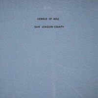
The Census of 1852 collection includes enumerations of California's 32 counties, arranged into 126 volumes. Schedule I enumerated the county's inhabitants, while schedule II enurmerated economic production. Many pages of this volume are damaged.
Date: 1852
-
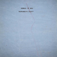
The Census of 1852 collection includes enumerations of California's 32 counties, arranged into 126 volumes. Schedule I enumerated the county's inhabitants, while schedule II enurmerated economic production. Many pages of this volume are damaged.
Date: 1852
-
The Census of 1852 collection includes enumerations of California's 32 counties, arranged into 126 volumes. Schedule I enumerated the county's inhabitants, while schedule II enurmerated economic production. Many pages of this volume are damaged.
Date: 1852
-
The Census of 1852 collection includes enumerations of California's 32 counties, arranged into 126 volumes. Schedule I enumerated the county's inhabitants, while schedule II enurmerated economic production. Many pages of this volume are damaged.
Date: 1852
-
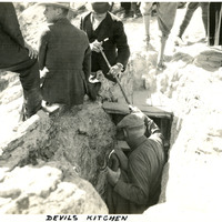
Caption: "Devil's Kitchen," c. 1923. This photograph shows several people descending into and standing around the entry to Devil's Kitchen, an extinct hot spring that left behind a cavern. Once a popular tourist attraction for its small opening that made visitors feel as if they were descending into the underworld, the site was closed in 1939 because the cavern periodically fills with dangerous levels of carbon dioxide.
Date: 1923
-
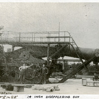
Caption: "Coast Defense: 14 Inch Disappearing Gun." Another copy of a C.D. Heath photograph, this image shows a heavy artillery gun, with two unidentified men standing next to it, at the Sandy Hook Proving Ground. Located at Sandy Hook, New Jersey, the Sandy Hook Proving Ground was used by the U.S. Army to test ordinance and materiel from 1874-1919. See also 96-07-08-alb05-101.
Date: 1910