Search All Items
- Filters:
- Language
- English 6219
- Spanish 19
- ENGLISH 2
- English 1
- contra_costa_schedule_1_volume_1 1
- Type
- Image 3871
- Still Image 1869
- Text 440
- Text 54
- Textual 2
- Image of the California Census from the records of the office of the California Secretary of State 1
Search Results 6201 to 6210 of 6312
-
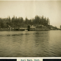
Caption: "Fort Ward, Wash.," c. 1908-1912. View from Puget Sound of a wharf and other buildings of Fort Ward. Originally known as Bean Point, Fort Ward was established by the U.S. Army Coastal Artillery Corps in 1890. Re-named Fort Ward in 1903, the facility included four coastal batteries designed to assist in protecting Puget Sound and the nearby Naval Shipyard from enemy attack. Fort Ward was placed on inactive status in the 1920s, but was revived by the U.S. Navy during World War II. The Navy discovered the fort's location was ideal for listening to radio communications from Japan, and it subsequently became a top secret listening post with a link directly to Washington, D.C. The Navy continued the fort's use as a listening post until 1956, when it was again taken over by the U.S. Army. The Army subsequently stopped all activity in 1958, ultimately selling portions of the fort to the Washington State Park System in 1960. It is now a state park.
Date: 1908
-
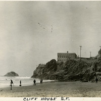
Caption: "Clife [sic] House S.F.," c. 1908-1912. View of San Francisco's Cliff House overlooking Ocean Beach. The building shown here is the fourth iteration of the Cliff House, a neo-classical design built after a fire destroyed the Victorian structure previously at the site in 1907. Reconstruction of the iconic restaurant began in 1908, and a new Cliff House opened in 1909 (the building in this photograph). This neo-classical building was extensively remodeled in the 1930s.
Date: 1908
-
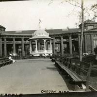
Caption: "A.Y.P.E. Seattle Oregon Bldg." View of Oregon Building and bandstand, part of the Alaska-Yukon-Pacific Exposition. Held in Seattle to celebrate the development of the Pacific Northwest, the fair attracted 3.7 million visitors over the course of its run from June to October 1909. Although most of the fair's buildings have since been destroyed, several of them now serve as part of the University of Washington campus.
Date: 1909
-
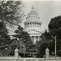
Caption: "State Capitol - Calif, " c. 1920. View of the California State Capitol Building. Much of the building is obscured by trees, but the dome is visible. Designed by M.F. Butler, California's State Capitol Building experienced significant delays while under construction. Crews broke ground on December 4, 1856, but the Legislature did not occupy the building until 1869, and the building was not fully completed until 1874.
Date: 1920
-
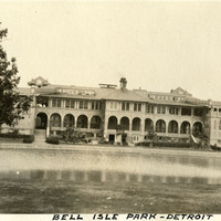
Caption: "Bell [sic] Isle Park - Detroit," c.1925. This photograph features the Belle Isle Casino, on the edge of Lake Tacoma on Belle Isle, in the Detroit River. The building is the second structure at the site, built in 1908 to replace a dilapidated wooden structure. The building is not a gambling facility, but is instead called a "casino" in the older sense of the word: a public building for meetings, dancing, reunions, and other recreation.
Date: 1925
-
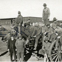
No caption, c. 1917. Group of men posing on 6" Howitzers at Camp Kearney. William McCarthy is standing in a dark suit just beneath the barrel of the middle gun. Camp Kearney was established by the U.S. Army in 1917 just north of San Diego. The post was largely abandoned by the government in 1920, used as a military and civilian airfield. It did not see increased military service again until the 1930s.
Date: 1917
-
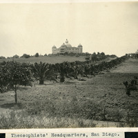
Caption: "Theosophists' Headquarters, San Diego.," c. 1905. Palm-lined driveway leading to two large buildings. The Raja Yoga Academy is visible in the center of the photograph, featuring a domed roof and domed turrets at each of the building's corners. At the right stands the Temple of Peace. Both are buildings within the Theosophist complex called Lomaland. The complex housed Theosophists from 1900 to 1942. The area is now part of Point Loma Nazarene University.
Date: 1905
-
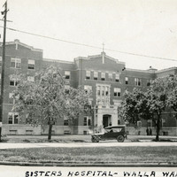
Caption: "Sisters Hospital -- Walla Walla.," ca. 1920. Five-story brick and stone building. This building is the second hospital built on the site. The first, built in the 1880s by the Sisters of Providence, burned in a 1915 fire. This second building (seen here), constructed in 1916, served as the main hospital building until a new facility was constructed in 1976. The resulting new complex of buildings is now called the Providence St. Mary Medical Center.
Date: 1920
-
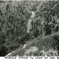
Caption: "Temple Drive to Cave of the Winds," c. 1923. Bird's eye view of a road at the bottom of a canyon, on a drive to Cave of the Winds. Two brothers discovered the entrance to the large cave system in 1880, in Williams Canyon just outside of Manitou Springs. Further exploration resulted in opening more caverns within the system, and the site became a tourist attraction, with guided tours having been on offer since 1881.
Date: 1923
-
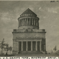
Caption: "General U.S. Grants [sic] Tomb, Riverside Drive. New York, Aug. 10, 1934." The remains of Ulysses S. Grant, 18th President of the U.S. and Commanding General of the Union Army during the last year of the Civil War, were laid to rest in this elaborate tomb. Grant died in 1885, but construction on the tomb did not begin until 1891. Grant's remains were transferred to the tomb on April 27, 1897.
Date: 8/10/1934