Search All Items
- Filters:
- Language
- English 6219
- Spanish 19
- ENGLISH 2
- English 1
- contra_costa_schedule_1_volume_1 1
- Type
- Image 3871
- Still Image 1869
- Text 440
- Text 54
- Textual 2
- Image of the California Census from the records of the office of the California Secretary of State 1
Search Results 6221 to 6230 of 6312
-
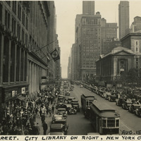
Caption: "42nd Street. City Library on right, New York City, N.Y. Aug. 15, 1934." Busy street scene along New York City's 42nd Street, showing numerous pedestrians, automobiles, and street trolleys. On the right side of the photograph can be seen the side of the New York Public Library's main building, opened in 1911. At the time of its opening, the Library's main reading room was the largest of its kind in the world.
Date: 8/15/1934
-
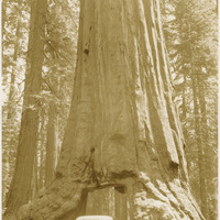
No Caption: c. 1935. Pictured are vehicles driving through the famous Wawona Tunnel Tree, a giant sequoia that stood in Mariposa Grove of Yosemite National Park. The tree's tunnel was cut in 1881 as a tourist attraction. In 1969, the tree fell during a severe winter storm. Before it fell, the ancient tree measured 234 ft. high, twenty-six ft. in diameter, and was approximately 2,100 years old.
Date: 1935
-
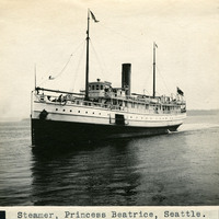
Caption: "Steamer, Princess Beatrice, Seattle.," c. 1908-1912. View of the Princess Beatrice, a steamship operated by the Canadian Pacific Railway (CPR) between Seattle, Washington, and Victoria, British Columbia. Built in 1903, she made her first trip in January 1904. The CPR operated several ships in the Pacific Northwest, all of which were christened with "Princess" in the name. As a result, the CPR naval fleet was often referred to as "The Pacific Princesses" or the "Princess Fleet."
Date: 1908
-
Caption: "San Diego Fair Grounds." and "39-9, U.S. Naval Training Station, Balboa Park, San Diego," c. 1917. With the advent of World War I, the U.S. Navy needed additional training grounds for sailors. In 1917, the City of San Diego offered to lease the Navy a portion of Balboa Park as a temporary training site until a new, more permanent facility could be constructed. This postcard shows groups of sailors drilling in formation while a small crowd watches.
Date: 1917
-
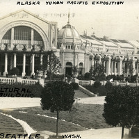
Caption: "Alaska Yukon Pacific Exposition," "Agricultural Building" and "A.Y.P.E. Seattle Wash." View of the Agricultural Building of the Alaska-Yukon-Pacific Exposition, often referred to as the "A-Y-P." Held in Seattle to celebrate the development of the Pacific Northwest, the fair attracted 3.7 million visitors over the course of its run from June to October 1909. Although most of the fair's buildings have since been destroyed, several of them now serve as part of the University of Washington campus.
Date: 1909
-
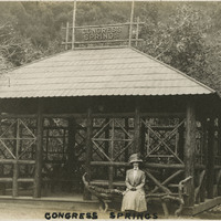
Caption: "Congress Springs.", c. 1910. Grace McCarthy seated on an unusual bench made from a tree branch and logs, in front of a timber shelter at Pacific Congress Springs, near Saratoga in California's Santa Clara Valley. Pacific Congress Springs, a mineral spring named after Congress Springs in New York, operated as a resort area from the nineteenth century until the 1930s. See also 96-07-08-alb05-108.
Date: 1910
-
The Census of 1852 collection includes enumerations of California's 32 counties, arranged into 126 volumes. Schedule I enumerated the county's inhabitants, while schedule II enurmerated economic production. Many pages of this volume are damaged.
Date: 1852
-
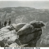
Caption: "Glacier Point - Overhanging Rock," c. 1935. Grace McCarthy poses for a photograph at Glacier Point's iconic overhanging rock. Glacier Point, on the south wall of the valley 3,200 feet above what is now known as Half Dome Village, provides panoramic views of the valley and many of its features. By the time this photograph was taken, safety railings had been installed at the Point to prevent visitors from tumbling over the cliff while trying to get the best views.
Date: 1935
-
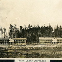
Caption: "Fort Casey Barracks," c. 1908-1912. View of two barracks buildings at Fort Casey, located on Whidbey Island in Puget Sound. Construction began on the fort in 1897. Fort Casey was part of the "triangle of fire," three coastal defense fortifications (Fort Casey, Fort Worden, and Fort Flagler) guarding the entrance to Puget Sound. The U.S. Army used the facility until the 1950s, when the fort was decommissioned. The area is now a state park.
Date: 1908
-
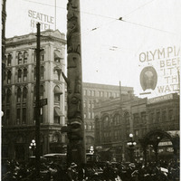
Caption: "Totem Pole -- Seattle, Wash.," c. 1915. View of the Tlingit totem pole in Seattle's Pioneer Square. The totem pole was stolen in 1899 by a group of businessmen, and erected in the square, then known as Pioneer Place. An arson destroyed this pole in 1938, but it was later replaced by another carved by the Tlingit tribe (who were also finally paid for the original pole).
Date: 1915