Search All Items
- Filters:
- Language
- English 6219
- Spanish 19
- ENGLISH 2
- English 1
- contra_costa_schedule_1_volume_1 1
- Type
- Image 3871
- Still Image 1869
- Text 440
- Text 54
- Textual 2
- Image of the California Census from the records of the office of the California Secretary of State 1
Search Results 6261 to 6270 of 6312
-
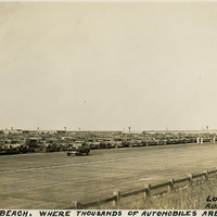
Caption: "Jones's [sic] Beach. Where Thousands of Automobiles are Parked. Long Island, N.Y. Aug. 17, 1934." Photograph of a large parking area full of automobiles on Jones Beach Island. The Long Island State Park Commission began to develop the area for a park in the 1920s, dredging enough sand to connect several of the barrier islands south of Long Island and raising the elevation of the islands by fourteen feet to create one large park. It opened to the public in 1929. It is now a state park, with an estimated six million visitors each year.
Date: 8/17/1934
-
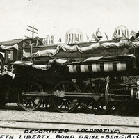
Caption: "Decorated Locomotive. Fifth Liberty Bond Drive -- Benicia, Calif." During World War I, the U.S. government raised funds for the war by issuing "liberty bonds." Citizens who purchased the bonds could later redeem them for the purchase price plus interest. Liberty Bond Drives were held to encourage people to purchase the bonds. This photograph shows a locomotive employed in the fifth Liberty Bond Drive, held in 1919. Decorated with bunting and flags to inspire patriotic feeling, Liberty Bond Trains crisscrossed the U.S. to round up funding.
Date: 1919
-
No Caption: This postcard shows a view of the Government Building and the Cascades (a terraced fountain leading up to the building), part of the Alaska-Yukon-Pacific Exposition. Held in Seattle to celebrate the development of the Pacific Northwest, the fair attracted 3.7 million visitors over the course of its run from June to October 1909. Although most of the fair's buildings have since been destroyed, several of them now serve as part of the University of Washington campus. See also 96-07-08-alb05-212.
Date: 1909
-
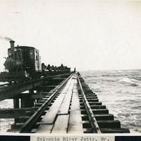
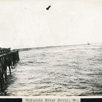
Caption: "Columbia River Jetty, Or.," c. 1910. View of a jetty built at the mouth of the Columbia River, carrying a railroad trestle. A train hauling cars loaded with large rocks is visible at the left side of the photograph. This is likely the so-called South Jetty, extending more than six miles into the ocean from Point Adams on the Oregon side of the river mouth. The jetty system at the mouth of the Columbia River was constructed between 1885 and 1917. Designed to funnel water from the Columbia River in a more concentrated fashion into the Pacific Ocean, the jetty system helped create a deeper, more stable shipping channel.
Date: 1910
-
Caption: "Seminole Indian Women Washing Clothes -- Everglades -- Fla. June 30, 1934." Two unidentified women and a small child washing clothing. Several articles of clothing are spread out to dry on a canoe lifted off the ground by sawhorses made of logs. They are likely Seminoles, a Native American tribe in Florida, although most of the tribe had been forcibly relocated from Florida to Oklahoma by 1842. Fewer than 200 remained in Florida after the Third Seminole War ended in 1858, but a resurgence of the tribe occurred in the early to mid twentieth century. The Florida Seminole tribe received federal recognition in 1957.
Date: 6/30/1934
-
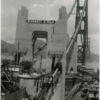
Caption: "Golden Gate Bridge, Construction, July 1, 1936." Image of one terminus of the Golden Gate Bridge, showing the anchoring site of the suspension wires. Completed in 1937, the Golden Gate Bridge spans the mouth of San Francisco Bay (called the Golden Gate), connecting San Francisco with Marin County to the north. It is one of the most recognizable bridges in the world, and was named in 1994 as one of the Modern Wonders of the World by the American Society of Civil Engineers.
Date: 7/1/1936
-
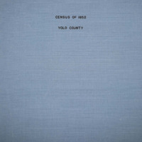
The Census of 1852 collection includes enumerations of California's 32 counties, arranged into 126 volumes. Schedule I enumerated the county's inhabitants, while schedule II enurmerated economic production. Many pages of this volume are damaged.
Date: 1852
-
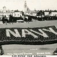
Caption: "San Diego Fair Grounds." and "39-6, 3,400 Men, Naval Training Station, Balboa Park, San Diego Cal.," c. 1917. With the advent of World War I, the U.S. Navy needed additional training grounds for sailors. In 1917, the City of San Diego offered to lease the Navy a portion of Balboa Park as a temporary training site until a new, more permanent facility could be constructed. This postcard shows 3,400 sailors lined up to form a Navy flag while at the temporary training ground.
Date: 1917
-
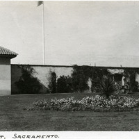
Caption: "Sutter [sic] Fort. Sacramento.," c. 1920. A gun tower at Sutter's Fort, and a gate bracketed by two cannons. John Sutter established the fort in 1839, calling it New Helvetia. After the discovery of gold at one of Sutter's mills (at Coloma, on the American River), almost all of the fort's inhabitants left for the gold fields in the foothills. The fort deteriorated until being restored from 1891-1893. The fort is now the site of a State Historic Park. See also 96-07-08-alb05-118.
Date: 1920
-
Caption: "Columbia River Jetty, Or.," c. 1910. View of a jetty built at the mouth of the Columbia River, carrying a railroad trestle. Train cars loaded with large rocks are visible at the left side of the photograph. This is likely the so-called South Jetty, extending more than six miles into the ocean from Point Adams on the Oregon side of the river mouth. The jetty system at the mouth of the Columbia River was constructed between 1885 and 1917. Designed to funnel water from the Columbia River in a more concentrated fashion into the Pacific Ocean, the jetty system helped create a deeper, more stable shipping channel.
Date: 1910