Search All Items
- Filters:
- Type
- Image 3882
- Still Image 2127
- Text 433
- Text 50
- Image of the California Census from the records of the office of the California Secretary of State 1
- Language
- English 6465
- Spanish 33
- ENGLISH 2
- English 2
- census_013 1
- contra_costa_schedule_1_volume_1 1
Search Results 6281 to 6290 of 6569
-
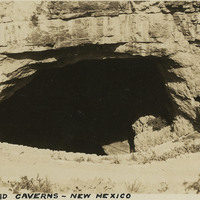
Caption: "Carlsbad Caverns -- New Mexico, May 30, 34." View looking into dark cave mouth of Carlsbad Cavern, a series of natural underground chambers including the "Big Room," the fifth-largest such chamber in North America with a length of 1,000 feet, a width of 625 feet, and a maximum height of 255 feet. The site was named Carlsbad Cave National Monument in 1923, and declared Carlsbad Caverns National Park in 1930.
Date: 5/30/1934
-
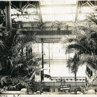
Caption: "Sutro Baths S.F.," c. 1910. Interior shot of the Sutro Baths, north of the Cliff House. Designed by Adolph Sutro in 1894, the bathhouses at one time covered three oceanfront acres just north of Ocean Beach and the Cliff House. Eventually, the Sutro Baths fell into disrepair and what was left of them burned down in 1966. Since 1973, the concrete ruins have been part of the Golden Gate National Recreation Area. See also 96-07-08-alb02-023.
Date: 1910
-
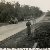
Caption: "Jefferson Davis Highway. U.S. No. 1. Virginia. July 20, 34." Grace McCarthy is standing next to a U.S. Route 1 sign along a highway in Virginia. The Jefferson Davis Highway project was begun by the United Daughters of the Confederacy (UDC). As auto tourism increased across the U.S., so to did the need for roads on which to drive. Private interests such as the UDC began to develop routes across the country, but with no central administrating organization the routes were haphazard and confusing. The UDC planned a route that was to stretch from Virginia across the southern U.S. to San Diego, but the entire route never materialized. The federal government stepped in to impose a numbering system on various routes across the nation. That portion of the planned Jefferson Davis Highway through Virginia was numbered as U.S. Route 1.
Date: 7/20/1934
-
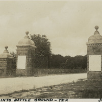
Caption: "San Jacinto Battle Ground -- Tex, June 11 34." View of the gated entry to the San Jacinto Battleground. The site was the location of the Battle of San Jacinto, in which the Texan Army (led by Sam Houston) defeated the Mexican army (led by General Antonio López de Santa Anna), paving the way for the formation of the Republic of Texas. A Texas Historic Site, the battleground was also declared a National Historic Landmark in 1960.
Date: 6/11/1934
-
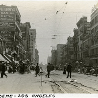
Caption: "Street Scene -- Los Angeles," c. 1910. Street-level view of an unidentified busy street in Los Angeles.
Date: 1910
-
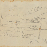
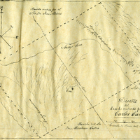
Hand-drawn sketch map of San Francisco de las Llagas boundaries. Volume 1, page 42.
Date: 1833
-
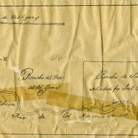
Hand-drawn sketch map of Rancho Del San Juan or San Juan boundaries. Volume 2, page 100.
Date: 1844
-
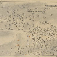
Hand-drawn sketch map of Canadita or Laguna Seca boundaries. Volume 1, page 168.
Date: 1833