Search All Items
- Filters:
- Type
- Image 3886
- Still Image 2481
- Text 427
- Text 50
- Image of the California Census from the records of the office of the California Secretary of State 1
- Language
- English 6833
- Spanish 18
- ENGLISH 3
- English 2
- census_013 1
- contra_costa_schedule_1_volume_1 1
Search Results 6761 to 6770 of 6946
-
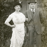
No caption, c. 1910. Humorous photograph of two unidentified men, one in a suit and bowler hat, the other in a dress with feather-plumed hat.
Date: 1910
-
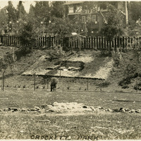
Caption: "Crockett Park," c. 1905-1906. Scene in a park in Crockett, California, showing a landscaped hill with flowers or rocks arranged to depict the California State Flag.
Date: 1906
-
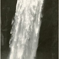
Caption: "Vernal Falls [sic]," c. 1917. Closeup view of Vernal Fall, a 317-foot waterfall on the Merced River, downstream of Nevada Fall.
Date: 1917
-
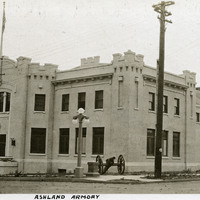
Caption: "Ashland Armory," c. 1915-1920. View of the National Guard Armory built in Ashland, Oregon. Designed by Oregon's first State Architect William C. Knighton, the armory has also been used as a community hall since its construction in 1912-1913.
Date: 1915
-
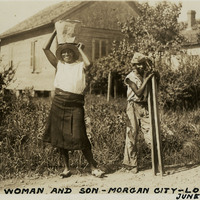
Caption: "Negro Woman and Son -- Morgan City -- Louisiana, June 13, 1934." Unidentified African-American woman and young man along a road in Morgan City. The woman is carrying a pail on her head, while the young man is carrying two wood planks.
Date: 6/13/1934
-
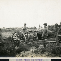
Caption: "Field Piece in Action." Unidentified location, c. 1905-1915. Shows a crew of men operating a 3" field gun, a heavy artillery gun set onto a carriage for mobile use. The U.S. military used these guns between 1905 and 1919, gradually phasing them out of use during the 1920s in favor of more modern weapons.
Date: 1915
-
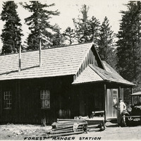
Caption: "Forest Ranger Station," c. 1917. Grace McCarthy (in the driver's seat of the automobile) and an unidentified man taking a break from driving by pausing next to a small plank house, identified as a forest ranger station by William McCarthy.
Date: 1917
-
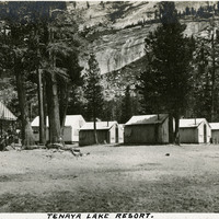
Caption: "Tenaya Lake Resort." Small cabins in front of rocky mountainside. Named after Chief Tenaya of Yosemite Valley's Ahwahnechee People, Tenaya Lake is located between Yosemite Valley and Tuolumne Meadows within Yosemite National Park. The surface elevation of the alpine lake is 8,150 feet.
Date: 1927
-
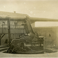
No Caption: c. 1910. Side view of a heavy coastal defense disappearing gun. Retracting or disappearing guns were a form of artillery developed in the nineteenth century in which heavy artillery guns were placed on rotating carriages that allowed retraction of the weapon after firing, to enable reloading while under enemy fire.
Date: 1910
-
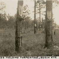
Caption: "Pine Trees Yielding Turpentine, Rosin [sic], Etc. Florida, July 13, 1934." A group of pine trees with bark removed in a "V"-shaped, or "catface" pattern to encourage production of resin, from which turpentine is made. Small buckets hang at the end of each "V" to catch the resin. This turpentine farm may actually be in Georgia, rather than Florida.
Date: 7/13/1934