
Collection Details
Diseños Collection
Date:
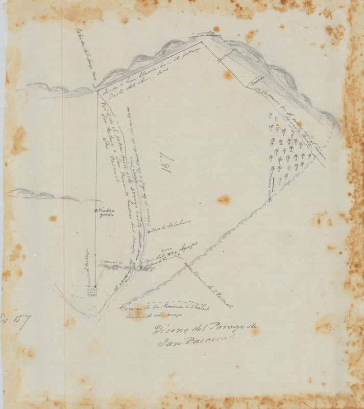
c. 1866-1871
Subject:
Land grants - California
Description:
Note: Certain images in this collection don’t display properly on iPhone. For best experience please use an Android phone or your desktop browser to view this site. Within the Diseños Collection there are 493 hand-drawn sketch maps, or diseños, that were created from approximately 1866-1871. These sketch maps were hand-copied from originals created from approximately 1827-1846. These are part of a larger collection that makes up the Spanish and Mexican Land Grant Records that also include expedientes, or written documents regarding the grant petition. At the end of the Mexican-American War in 1848, California became a territory of the United States after Mexico and the United States signed the Treaty of Guadalupe Hidalgo. Among other things, the treaty directed the U.S. government to honor legitimate land claims of Mexican citizens in the territory. Official copies of the provincial records kept in Monterey by the Spanish and Mexican governments were used by the new government to confirm land claims. Included in the title papers are sketch maps (diseños) and expedientes. The Mexican land grant process had a major influence on the development of California land by shaping settlement patterns and land ownership. As some of the earliest maps in California, diseños are essential to understanding the complex system of land ownership in the state today.About the Spanish and Mexican Land Grants Records As U.S. government officials collected the provincial records, Congress passed the Land Act of 1851 creating the Board of Land Commissioners. The Board would review the records and resolve land claims in the newly acquired region. In addition, this act entrusted the U.S. Surveyor General with surveying confirmed land grants. Landowners had two years to present their claim to the board by providing their copy of the grant with the governor’s seal. Failure to present their claims within those two years would result in forfeiture of the land, which would become public land. The Board of Land Commissioners operated for a total of five years. During this time, they operated mostly out of San Francisco but also operated out of Los Angeles for a brief time in 1852. Former Mexican citizens had to rely on translators and lawyers to help them through the submission process and later the appeal process in the federal courts, a process that on average took thirty years to complete. In general, petitioners had to wait seventeen years for the final patent for their land. The travel expenses coupled with legal fees led many to bankruptcy. Falling cattle prices and a few years of drought crippled many of the most prominent ranchos. As a result, most of the rancho lands were sold off at reduced prices to those who could afford the legal fees. During this period much of the land transferred to incoming American settlers. Others dealt with squatters taking their land from them. In the end, the Land Commissioners reviewed 813 grant claims, but only approved 553. Diseños were used throughout the land grant process under the Spanish, Mexican and U.S. governments to show boundaries. These hand drawn maps mainly use naturally occurring boundaries such as rivers, mountains, rock outcropping, and trees as markers. Many of the diseños have labeled neighboring properties and as part of the initial land grant process all borders were agreed upon by surrounding landowners. The diseños also show existing travel routes, locations of houses and local place names. Using natural landmarks as markers would become problematic under the U.S. government, as changing landscapes made proving the borders difficult. For this reason, the U.S. Surveyor General conducted their own survey of the confirmed grant properties in an effort to settle boundaries. Chapter 281, Statutes of 1865-1866, required the Secretary of State to engross all original grants and documents relating to the titles of land in the state derived from the Spanish or Mexican governments, along with accurate translations. The documents were housed at the Office of the United States Surveyor General in San Francisco, and Rufus C. Hopkins, Keeper of the Archives in that office, executed the work from 1866 to 1871. The diseños in the State Archives collection are copies of the original hand-drawn maps found in the individual expedientes. At the request of the legislature, the records from Monterey were transcribed and deposited at the State Archives in 1871. California's Evidence Code §1605, provides that the Spanish-Mexican land grant records in the State Archives are receivable as prima facie evidence with like force and effect as the originals.
Publisher:
California State Archives, a division of the California Secretary of State's Office
Format:
JPEG, scanned at 400 DPI, 24-bit color
Language:
Spanish
Type:
Still Image