
Bookmarks
Showing Bookmarks 1 to 3 of 3
-
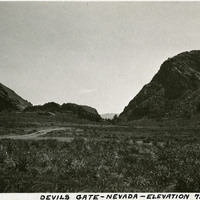
Caption: "Devils Gate -- Nevada -- Elevation 7540 Feet." Devil's Gate is a rock formation near Silver City, Nevada. In the nineteenth century a portion of the formation was blasted away to create enough space for a wagon road, which became a toll road serving as an entryway to the Nevada silver fields.
Date: 1927
-
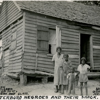
Caption: "Walterboro Negroes and Their Shack. If the Window Wont [sic] Stay Closed, Put a Stick Up to It, You Wont [sic] Break the Glass. House Foundation Gone But They Live Merrily On. July 17, 1934." Unidentified family posing in front of a dilapidated home in Walterboro.
Date: 7/17/1934
-
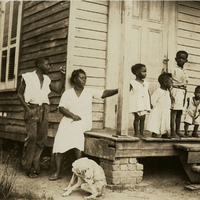
Unidentified African-American woman, several children, and a dog, posing on and around the porch of a wood-plank home. *Please note:* Original caption removed due to sensitive content. To view the original photograph with caption, please contact the California State Archives Reference Desk.
Date: 6/17/1934