
Bookmarks
Showing Bookmarks 1 to 2 of 2
-
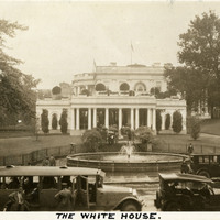
*Caption: "The White House." East Wing of the White House in Washington, D.C. The Neoclassical-style residence and work place of the United States President, designed by James Hoban, was constructed between 1792 and 1800. See also 96-07-08-alb09-222 and 96-07-08-alb11-183.
Date: 1934
-
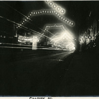
Caption: "Fillmore St," c. 1908. A view of San Francisco's Fillmore Street at night, which has been decorated with garlands of electric lights along the length of the street.
Date: 1908