Bookmarks
Showing Bookmarks 1 to 14 of 14
-
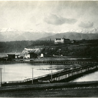
No Caption: See also 96-07-08-alb08-082 with caption: "The Olympic Snow-capped Mountains," Washington, c. 1908. Vista of the Olympic Mountains in the distance. In the middle distance to the right can be seen the Eisenbeis Castle (now known as the Manresa Castle Restaurant and Lounge), built in 1892 by Charles Eisenbeis, a businessman and Port Townsend's first mayor. The photograph is centered around what appears to be a resort hotel situated a short distance from the Eisenbeis Castle.
Date: 1908
-
No Caption: View of a portion of the fairgrounds of the Alaska-Yukon-Pacific Exposition in Seattle, showing elegantly attired fairgoers strolling pathways and resting on benches. Held in Seattle to celebrate the development of the Pacific Northwest, the fair attracted 3.7 million visitors over the course of its run from June to October 1909. Although most of the fair's buildings have since been destroyed, several of them now serve as part of the University of Washington campus.
Date: 1909
-
Caption: "CHICAGO AND BENNINGTON, OFFICERS & CREW." View of the USS Chicago. The flagship of the US fleet in the Pacific at the time, the USS Chicago was called to the fort after a boiler explosion on the USS Bennington killed sixty-six and wounded dozens more. A board of inquiry into the cause of the explosion was convened on board the Chicago. The board found that no error on the part of the Bennington's crew contributed to the explosion.
Date: 1905
-
Caption: "Tree Bareing [sic] 8 Varieties of Fruit. Shields Date Gardens - Blythe, Calif. May 31, 1935," shows William McCarthy standing next to a tree that bears eight varieties of fruit.
Date: 1935
-
Hand-drawn sketch map of Rio de las Cosumnes al Norte or Omachumnes boundaries. Volume 2, page 22.
Date: 1844
-
Caption: "Hudson River Boat," c. 1925. The Washington Irving, a three-stack steamer ship, is shown in this photograph. The ship was in operation from 1913 to 1926, when it collided with an oil barge and sank.
Date: 1925
-
Caption: "Glacier Point (x)," c. 1917. In this photograph of the walls of Yosemite Valley, taken from the valley floor, William McCarthy has marked the location of Glacier Point with an "x." Glacier Point, on the south wall of the valley 3,200 feet above what is now known as Half Dome Village, provides panoramic views of the valley and many of its features.
Date: 1917
-
Hand-drawn sketch map of San Juan Bautista boundaries. Volume 2, page 58.
Date: 1843
-
Caption: "General U.S. Grants [sic] Tomb, Riverside Drive. New York, Aug. 10, 1934." The remains of Ulysses S. Grant, 18th President of the U.S. and Commanding General of the Union Army during the last year of the Civil War, were laid to rest in this elaborate tomb. Grant died in 1885, but construction on the tomb did not begin until 1891. Grant's remains were transferred to the tomb on April 27, 1897.
Date: 8/10/1934
-
Hand-drawn sketch map of Salinas y Visitacion boundaries. Volume 1, Page 2.
Date: 1834
-
-
Caption: "Echo Park, Los Angeles," c. 1915, shows palms and trees lining a small lake in Echo Park, Los Angeles.
Date: 1915
-
Hand-drawn sketch map of Cienega de los Paicines boundaries. Volume 1, page 780.
Date: 1840
-
Hand-drawn sketch map of Land-Los Angeles boundaries. Volume 2, page 175.
Date: 1839