Bookmarks

Showing Bookmarks 1 to 10 of 10

  • McCarthy Album 07, Photograph 161

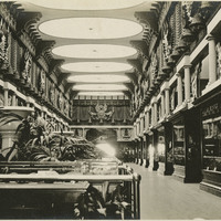
    Caption: "Canada," shows exhibits inside the Canadian Pavilion at the Panama-Pacific International Exposition. See also 96-07-08-alb01-139.

    Date: 1915

  • McCarthy Album 05, Photograph 241

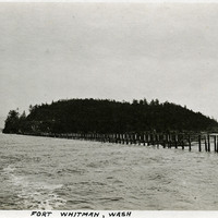
    Caption: "Fort Whitman, Wash," c. 1910. View of Goat Island in Puget Sound, Washington. Goat Island was the location of Fort Whitman, a small coastal defense fortification built in 1909. The fort consisted of a single battery and a mine field patrol and observation outpost. The buildings were torn down in 1945 at the conclusion of World War II.

    Date: 1910

  • Guaspita, or Sausal Redondo pr Santa Elena Rancho

    Hand-drawn sketch map of Guaspita, or Sausal Redondo or Santa Elena boundaries. Volume 2, page 30.

    Date: 1837

  • eichler_f3274_342_14

    Caption: "Administrative Entrance - Armory - California National Guard - Long Beach." Design and drawing by Alfred Eichler. Project for California Military Department.

    Date: 1930

  • San Clemente or Tamalpais Rancho

    Hand-drawn sketch map of San Clemente or Tamalpais boundaries. Volume 2, page 123.

    Date: 1845

  • eichler_f3274_449_7d

    Caption: "Location Plan. Gymnasium, Whittier State School." Blueprint, Fred C. Nelles School for Boys; design and drawing by Alfred Eichler. Built. Project for California Youth Authority - Institutions.

    Date: 1934

  • eichler_f3274_124_002

    Caption: "Covered Passage - Music Bldg., Fresno." Drawing of Music Building, Fresno State College. Design and drawing by Alfred Eichler. Project for Department of Education.

    Date: 1946

  • eichler_f3274_184

    Drawing of Industrial Education Unit, Mesa Campus, Santa Barbara State College. Drawing by Alfred Eichler. Built. Project for Department of Education.

    Date: 1940

  • Mill site near Mission San Jose Rancho

    Hand-drawn sketch map of Miil site near Mission San Jose boundaries. Volume 1, page 584.

    Date: 1840

  • Tzbaco Rancho

    Hand-drawn sketch map of Tzbaco boundaries. Volume 2, page 9.

    Date: 1843