Bookmarks

Showing Bookmarks 1 to 11 of 11

  • McCarthy Album 10, Photograph 044

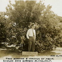
    Caption: "Tree Bareing [sic] 8 Varieties of Fruit. Shields Date Gardens - Blythe, Calif. May 31, 1935," shows William McCarthy standing next to a tree that bears eight varieties of fruit.

    Date: 1935

  • Rio de las Cosumnes al Norte or Omachumnes Rancho

    Hand-drawn sketch map of Rio de las Cosumnes al Norte or Omachumnes boundaries. Volume 2, page 22.

    Date: 1844

  • McCarthy Album 09, Photograph 140

    Caption: "Hudson River Boat," c. 1925. The Washington Irving, a three-stack steamer ship, is shown in this photograph. The ship was in operation from 1913 to 1926, when it collided with an oil barge and sank.

    Date: 1925

  • McCarthy Album 09, Photograph 307

    Caption: "Glacier Point (x)," c. 1917. In this photograph of the walls of Yosemite Valley, taken from the valley floor, William McCarthy has marked the location of Glacier Point with an "x." Glacier Point, on the south wall of the valley 3,200 feet above what is now known as Half Dome Village, provides panoramic views of the valley and many of its features.

    Date: 1917

  • San Juan Bautista Rancho

    Hand-drawn sketch map of San Juan Bautista boundaries. Volume 2, page 58.

    Date: 1843

  • McCarthy Album 11, Photograph 209

    Caption: "General U.S. Grants [sic] Tomb, Riverside Drive. New York, Aug. 10, 1934." The remains of Ulysses S. Grant, 18th President of the U.S. and Commanding General of the Union Army during the last year of the Civil War, were laid to rest in this elaborate tomb. Grant died in 1885, but construction on the tomb did not begin until 1891. Grant's remains were transferred to the tomb on April 27, 1897.

    Date: 8/10/1934

  • Salinas y Visitacion Rancho

    Hand-drawn sketch map of Salinas y Visitacion boundaries. Volume 1, Page 2.

    Date: 1834

  • Laguna Rancho

    Hand-drawn sketch map of Laguna of boundaries. Volume 2, page 46.

    Date: 1844

  • McCarthy Album 07, Photograph 209

    Caption: "Echo Park, Los Angeles," c. 1915, shows palms and trees lining a small lake in Echo Park, Los Angeles.

    Date: 1915

  • Cienega de los Paicines Rancho

    Hand-drawn sketch map of Cienega de los Paicines boundaries. Volume 1, page 780.

    Date: 1840

  • Land- Los Angeles Rancho

    Hand-drawn sketch map of Land-Los Angeles boundaries. Volume 2, page 175.

    Date: 1839